
Make a donation
Gear up for your next adventure:
As an Amazon Associate, this site earns from qualifying purchases at no extra cost to you.
Segusino topographic map
Click on the map to display elevation.
Make a donation
Gear up for your next adventure:
As an Amazon Associate, this site earns from qualifying purchases at no extra cost to you.
About this map
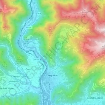
Name: Segusino topographic map, elevation, terrain.
Location: Segusino, Pieve del Grappa, Treviso, Veneto, 31040, Italia (45.89648 11.94374 45.96804 12.00759)
Average elevation: 1,929 ft
Minimum elevation: 548 ft
Maximum elevation: 4,905 ft
Make a donation
Gear up for your next adventure:
As an Amazon Associate, this site earns from qualifying purchases at no extra cost to you.
Other topographic maps
Click on a map to view its topography, its elevation and its terrain.
Make a donation
Gear up for your next adventure:
As an Amazon Associate, this site earns from qualifying purchases at no extra cost to you.
Make a donation
Gear up for your next adventure:
As an Amazon Associate, this site earns from qualifying purchases at no extra cost to you.
Make a donation
Gear up for your next adventure:
As an Amazon Associate, this site earns from qualifying purchases at no extra cost to you.
Make a donation
Gear up for your next adventure:
As an Amazon Associate, this site earns from qualifying purchases at no extra cost to you.
Make a donation
Gear up for your next adventure:
As an Amazon Associate, this site earns from qualifying purchases at no extra cost to you.
Make a donation
Gear up for your next adventure:
As an Amazon Associate, this site earns from qualifying purchases at no extra cost to you.
Col Visentin
Italia > Veneto > Treviso > Vittorio Veneto
La cima del Col Visentin a 1.763 metri di altitudine, si trova in una posizione dominante sulla pianura trevigiana e sulla Valbelluna, e domina la sella di Fadalto, la Val Lapisina, il Lago Morto ed il Lago di Santa Croce, nonché il Montello.
Average elevation: 4,360 ft
Monte Pizzoc
Italia > Veneto > Treviso > Fregona
Il Pizzoc è un monte delle Prealpi Trevigiane. Raggiunge i 1.565 m d'altitudine, rappresentando uno dei punti più elevati del comune di Fregona e della provincia di Treviso, a cui appartiene.
Average elevation: 4,068 ft
Make a donation
Gear up for your next adventure:
As an Amazon Associate, this site earns from qualifying purchases at no extra cost to you.
Villa di Villa
A 160 metri di altitudine, su un'altura a nord est del centro, sorge una piccola chiesa dedicata alla Madonna delle Grazie e proprietà di una famiglia qui residente: il piccolo edificio sacro, di antica fondazione, fu ricostruito nel Novecento, a seguito di un terremoto.
Average elevation: 410 ft
Make a donation
Gear up for your next adventure:
As an Amazon Associate, this site earns from qualifying purchases at no extra cost to you.
Make a donation
Gear up for your next adventure:
As an Amazon Associate, this site earns from qualifying purchases at no extra cost to you.
Villa di Villa
Italia > Veneto > Treviso > Cordignano
A 160 metri di altitudine, su un'altura a nord est del centro, sorge una piccola chiesa dedicata alla Madonna delle Grazie e proprietà di una famiglia qui residente: il piccolo edificio sacro, di antica fondazione, fu ricostruito nel Novecento, a seguito di un terremoto.
Average elevation: 410 ft
Make a donation
Gear up for your next adventure:
As an Amazon Associate, this site earns from qualifying purchases at no extra cost to you.
Make a donation
Gear up for your next adventure:
As an Amazon Associate, this site earns from qualifying purchases at no extra cost to you.
Make a donation
Gear up for your next adventure:
As an Amazon Associate, this site earns from qualifying purchases at no extra cost to you.
Make a donation
Gear up for your next adventure:
As an Amazon Associate, this site earns from qualifying purchases at no extra cost to you.