
Make a donation
Gear up for your next adventure:
As an Amazon Associate, this site earns from qualifying purchases at no extra cost to you.
Alf topographic map
Click on the map to display elevation.
Make a donation
Gear up for your next adventure:
As an Amazon Associate, this site earns from qualifying purchases at no extra cost to you.
About this map
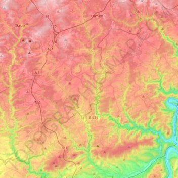
Name: Alf topographic map, elevation, terrain.
Location: Alf, Landkreis Bernkastel-Wittlich, Rijnland-Palts, Duitsland (50.00678 6.87887 50.22787 7.12972)
Average elevation: 1,250 ft
Minimum elevation: 285 ft
Maximum elevation: 1,962 ft
Make a donation
Gear up for your next adventure:
As an Amazon Associate, this site earns from qualifying purchases at no extra cost to you.
Other topographic maps
Click on a map to view its topography, its elevation and its terrain.
Mont Royal
Duitsland > Rijnland-Palts > Landkreis Bernkastel-Wittlich > Traben-Trarbach
Average elevation: 554 ft
Hartz
Duitsland > Rijnland-Palts > Landkreis Bernkastel-Wittlich > Pilmeroth
Average elevation: 1,263 ft
Wolf
Duitsland > Rijnland-Palts > Landkreis Bernkastel-Wittlich > Traben-Trarbach
Average elevation: 659 ft
Make a donation
Gear up for your next adventure:
As an Amazon Associate, this site earns from qualifying purchases at no extra cost to you.
Hunolstein
Duitsland > Rijnland-Palts > Landkreis Bernkastel-Wittlich > Morbach
Average elevation: 1,332 ft
Hinzerath
Duitsland > Rijnland-Palts > Landkreis Bernkastel-Wittlich > Morbach
Average elevation: 1,778 ft