
Make a donation
Gear up for your next adventure:
As an Amazon Associate, this site earns from qualifying purchases at no extra cost to you.
Pilmeroth topographic map
Click on the map to display elevation.
Make a donation
Gear up for your next adventure:
As an Amazon Associate, this site earns from qualifying purchases at no extra cost to you.
About this map
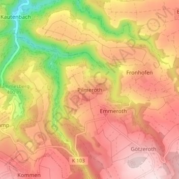
Name: Pilmeroth topographic map, elevation, terrain.
Average elevation: 1,325 ft
Minimum elevation: 650 ft
Maximum elevation: 1,755 ft
Make a donation
Gear up for your next adventure:
As an Amazon Associate, this site earns from qualifying purchases at no extra cost to you.
Other topographic maps
Click on a map to view its topography, its elevation and its terrain.
Make a donation
Gear up for your next adventure:
As an Amazon Associate, this site earns from qualifying purchases at no extra cost to you.
Trarbach
Duitsland > Rijnland-Palts > Landkreis Bernkastel-Wittlich > Traben-Trarbach
Average elevation: 1,010 ft
Make a donation
Gear up for your next adventure:
As an Amazon Associate, this site earns from qualifying purchases at no extra cost to you.
Graach an der Mosel
Duitsland > Rijnland-Palts > Landkreis Bernkastel-Wittlich
Average elevation: 869 ft
Make a donation
Gear up for your next adventure:
As an Amazon Associate, this site earns from qualifying purchases at no extra cost to you.
Make a donation
Gear up for your next adventure:
As an Amazon Associate, this site earns from qualifying purchases at no extra cost to you.
Traben
Duitsland > Rijnland-Palts > Landkreis Bernkastel-Wittlich > Traben-Trarbach
Average elevation: 627 ft
Kues
Duitsland > Rijnland-Palts > Landkreis Bernkastel-Wittlich > Bernkastel-Kues
Average elevation: 791 ft
Wehlen
Duitsland > Rijnland-Palts > Landkreis Bernkastel-Wittlich > Bernkastel-Kues
Average elevation: 725 ft
Make a donation
Gear up for your next adventure:
As an Amazon Associate, this site earns from qualifying purchases at no extra cost to you.
Dodenburg
Duitsland > Rijnland-Palts > Landkreis Bernkastel-Wittlich > Dodenburg
Average elevation: 1,033 ft
Make a donation
Gear up for your next adventure:
As an Amazon Associate, this site earns from qualifying purchases at no extra cost to you.
Hochscheid
Duitsland > Rijnland-Palts > Landkreis Bernkastel-Wittlich > Hochscheid
Average elevation: 1,864 ft
Make a donation
Gear up for your next adventure:
As an Amazon Associate, this site earns from qualifying purchases at no extra cost to you.