
Bailey topographic map
Click on the map to display elevation.
About this map
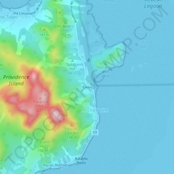
Name: Bailey topographic map, elevation, terrain.
Location: Bailey, Rocky Point, San Andrés and Providencia, Colombia (13.33158 -81.37820 13.37158 -81.33820)
Average elevation: 184 ft
Minimum elevation: 0 ft
Maximum elevation: 1,132 ft
Other topographic maps
Click on a map to view its topography, its elevation and its terrain.
Providence Island
Colombia > San Andrés and Providencia > Rocky Point
Providencia's maximum elevation is 360 metres (1,180 ft) above sea level. The smaller Santa Catalina Island to the northwest is connected by a 100-metre (330 ft) footbridge to its larger sister Providencia Island. Providencia Island has an area of 17 square kilometres (6.6 sq mi); the two islands cover an area…
Average elevation: 108 ft