
Make a donation
Gear up for your next adventure:
As an Amazon Associate, this site earns from qualifying purchases at no extra cost to you.
Providence Island topographic map
Click on the map to display elevation.
Make a donation
Gear up for your next adventure:
As an Amazon Associate, this site earns from qualifying purchases at no extra cost to you.
Providence Island
Providencia's maximum elevation is 360 metres (1,180 ft) above sea level. The smaller Santa Catalina Island to the northwest is connected by a 100-metre (330 ft) footbridge to its larger sister Providencia Island. Providencia Island has an area of 17 square kilometres (6.6 sq mi); the two islands cover an area of 22 square kilometres (8.5 sq mi) and form the municipality of Santa Isabel, which had a population of 4,927 at the Census of 2005. The island is served by El Embrujo Airport, which the Colombian Government plans to expand in order to take international flights.
Make a donation
Gear up for your next adventure:
As an Amazon Associate, this site earns from qualifying purchases at no extra cost to you.
About this map
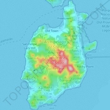
Name: Providence Island topographic map, elevation, terrain.
Average elevation: 108 ft
Minimum elevation: 0 ft
Maximum elevation: 1,132 ft
Make a donation
Gear up for your next adventure:
As an Amazon Associate, this site earns from qualifying purchases at no extra cost to you.
Other topographic maps
Click on a map to view its topography, its elevation and its terrain.