Geolocate

Mishawaka topographic map

Click on the map to display elevation.

About this map

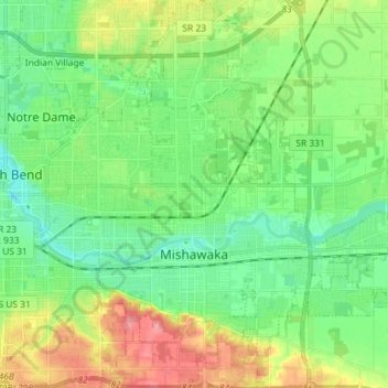
Name: Mishawaka topographic map, elevation, terrain.

Location: Mishawaka, Saint Joseph County, Indiana, United States (41.62406 -86.21585 41.73597 -86.09746)

Average elevation: 764 ft

Minimum elevation: 676 ft

Maximum elevation: 932 ft

Saint Joseph County trails, hiking, mountain biking, running and outdoor activities

Other topographic maps

Click on a map to view its topography, its elevation and its terrain.

Granger

United States > Indiana > Saint Joseph County

Average elevation: 801 ft

Granger

United States > Indiana > Saint Joseph County

Average elevation: 801 ft

Gear up for your next adventure:

🔥Camping Stove - Portable stove for camping and backcountry cooking
🔪Outdoor Multitools - Essential survival tools for gear repair and field use
❄️Traction Cleats - Prevent slips on icy trails during winter hikes
🔋Solar Power Banks - Keep your GPS and phone charged in remote wilderness areas
🧭GPS Watch Accessories - Bands and chargers for GPS watches

As an Amazon Associate, this site earns from qualifying purchases at no extra cost to you.