
Granger topographic map
Click on the map to display elevation.
About this map
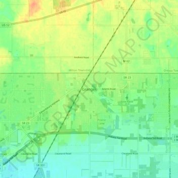
Name: Granger topographic map, elevation, terrain.
Location: Granger, Saint Joseph County, Indiana, 46530, United States (41.71338 -86.15084 41.79338 -86.07084)
Average elevation: 801 ft
Minimum elevation: 748 ft
Maximum elevation: 873 ft
Saint Joseph County trails, hiking, mountain biking, running and outdoor activities
Other topographic maps
Click on a map to view its topography, its elevation and its terrain.
South Bend
United States > Indiana > Saint Joseph County
On September 29, 1929, South Bend completed its "track elevation program". This was a railroad infrastructure project which saw the removal of Grand Trunk Western Railroad tracks from Division Street, the removal of level crossings from Chapin to Miami streets, the creation of a modern freight layout, and the…
Average elevation: 774 ft