Geolocate

Pero topographic map

Click on the map to display elevation.

About this map

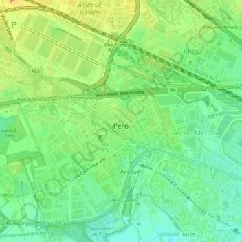
Name: Pero topographic map, elevation, terrain.

Location: Pero, Milan, Lombardy, 20016, Italy (45.49736 9.05523 45.52422 9.09877)

Average elevation: 472 ft

Minimum elevation: 430 ft

Maximum elevation: 509 ft

Other topographic maps

Click on a map to view its topography, its elevation and its terrain.

Monte Stella

Italy > Lombardy > Milan > Milan

Average elevation: 440 ft

Castelletto di Cuggiono

Italy > Lombardy > Milan

Average elevation: 466 ft

Fagnano

Italy > Lombardy > Milan > San Vito

Average elevation: 394 ft

Zivido

Italy > Lombardy > Milan > San Giuliano Milanese

Average elevation: 308 ft

Ospiate

Italy > Lombardy > Milan > Bollate

Average elevation: 512 ft

Mazzo

Italy > Lombardy > Milan > Rho

Average elevation: 509 ft

Cascina Confaloniera

Italy > Lombardy > Milan > Rosate

Average elevation: 351 ft

Mariotto

Italy > Lombardy > Milan > San Colombano al Lambro

Average elevation: 203 ft

Pantanedo

Italy > Lombardy > Milan > Rho > Mazzo

Average elevation: 502 ft

San Pietro all'Olmo

Italy > Lombardy > Milan > Cornaredo

Average elevation: 466 ft

Vaiano Valle

Italy > Lombardy > Milan > Milan > Vaiano Valle

Average elevation: 361 ft

Gear up for your next adventure:

📱Heavy-Duty Phone Cases - Drop-proof and waterproof protection for outdoor navigation
🦶Carbon Trekking Poles - Reduce knee impact on steep descents with ultra-light poles
🛏️Cold Weather Sleeping Bag - Warm sleeping bag for cold conditions
🏫Relief Map Kits - Hands-on tools for teaching landforms and elevation
🪑Ultralight Camp Chairs - Portable seating for resting after a long day of mapping

As an Amazon Associate, this site earns from qualifying purchases at no extra cost to you.