
Make a donation
Gear up for your next adventure:
As an Amazon Associate, this site earns from qualifying purchases at no extra cost to you.
Frampton Cotterell topographic map
Click on the map to display elevation.
Make a donation
Gear up for your next adventure:
As an Amazon Associate, this site earns from qualifying purchases at no extra cost to you.
About this map
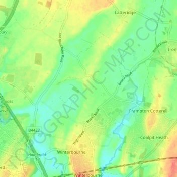
Name: Frampton Cotterell topographic map, elevation, terrain.
Average elevation: 190 ft
Minimum elevation: 125 ft
Maximum elevation: 279 ft
Make a donation
Gear up for your next adventure:
As an Amazon Associate, this site earns from qualifying purchases at no extra cost to you.
Other topographic maps
Click on a map to view its topography, its elevation and its terrain.
Goblin Ledge
United Kingdom > England > South Gloucestershire > Severn Beach > New Passage
Average elevation: 7 ft
Buckover
United Kingdom > England > South Gloucestershire > Thornbury > Milbury Heath
Average elevation: 213 ft
Make a donation
Gear up for your next adventure:
As an Amazon Associate, this site earns from qualifying purchases at no extra cost to you.