Geolocate

Corinth topographic map

Click on the map to display elevation.

About this map

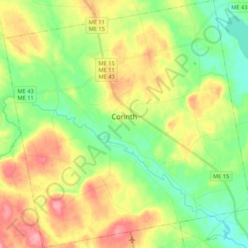
Name: Corinth topographic map, elevation, terrain.

Location: Corinth, Penobscot County, Maine, 04427, United States (44.92696 -69.08623 45.03385 -68.93537)

Average elevation: 249 ft

Minimum elevation: 115 ft

Maximum elevation: 436 ft

Penobscot County trails, hiking, mountain biking, running and outdoor activities

Other topographic maps

Click on a map to view its topography, its elevation and its terrain.

Lincoln

United States > Maine > Penobscot County > Lincoln

Average elevation: 272 ft

Meadow Brook

United States > Maine > Penobscot County

Average elevation: 325 ft

Houston Island

United States > Maine > Penobscot County > Winn

Average elevation: 243 ft

Carroll

United States > Maine > Penobscot County

Average elevation: 778 ft

Fairmont Park

United States > Maine > Penobscot County > Bangor

Average elevation: 148 ft

Gear up for your next adventure:

🧦Hiking Socks - Comfortable socks to prevent blisters on long hikes
🧺Microfiber Travel Towels - Compact and fast-drying towels for trail use
🪶Wildlife Field Guides - Learn animal tracking and species ID
🛠️Outdoor Gear Repair Kit - Essential tools to fix gear on the trail
🔊Portable Camp Speaker - Music and alerts at camp

As an Amazon Associate, this site earns from qualifying purchases at no extra cost to you.