Geolocate

Las Navas topographic map

Click on the map to display elevation.

About this map

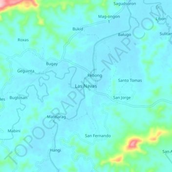
Name: Las Navas topographic map, elevation, terrain.

Location: Las Navas, Northern Samar, Eastern Visayas, Philippines (12.29818 124.99105 12.37818 125.07105)

Average elevation: 82 ft

Minimum elevation: 0 ft

Maximum elevation: 787 ft

Other topographic maps

Click on a map to view its topography, its elevation and its terrain.

Biri

Philippines > Northern Samar

Average elevation: 3 ft

Catubig River

Philippines > Northern Samar

Average elevation: 125 ft

Catarman

Philippines > Northern Samar

Average elevation: 164 ft

Cagnipa Island

Philippines > Northern Samar > Biri > Santo Niño

Average elevation: 16 ft

Sitio Rabbit

Philippines > Northern Samar > Victoria

Average elevation: 89 ft

Tarnate

Philippines > Northern Samar > San Vicente

Average elevation: 89 ft

Capul Island

Philippines > Northern Samar > Capul

Average elevation: 46 ft

Palanit

Philippines > Northern Samar

Average elevation: 171 ft

Capul

Philippines > Northern Samar

Average elevation: 16 ft

Cagnipa Island

Philippines > Northern Samar > Biri > Santo Niño

Average elevation: 16 ft

Capul Island

Philippines > Northern Samar > Capul

Average elevation: 46 ft

Catarman

Philippines > Northern Samar

Average elevation: 167 ft

Catarman

Philippines > Northern Samar

Average elevation: 167 ft

Gear up for your next adventure:

🌎3D Topographic Globes - Raised relief globes for a tactile understanding of geography
🪄Magnetic Compass - Accurate compass for navigation
🗻Climbing Gear Basics - Essential gear for beginner climbers
🏕️Tent Footprint - Protect your tent base from wear
🌄Hiking Binoculars - Compact binoculars for scenic views and trail spotting

As an Amazon Associate, this site earns from qualifying purchases at no extra cost to you.