
Boone topographic map
Click on the map to display elevation.
Boone
Boone, located in Watauga County, North Carolina, is set within the rugged Appalachian Mountains, specifically the Blue Ridge range. With an elevation of approximately 3,300 feet (1,016 meters), it stands as one of the highest towns of its size in the eastern United States. The terrain is dominated by steep slopes and ridges, creating dramatic landscapes. The town's topography includes forested hills, valleys, and rocky outcrops, which contribute to its scenic beauty and outdoor recreational opportunities. Boone's location also influences its climate, resulting in cooler temperatures compared to surrounding lower regions, especially during the winter months when snowfall and sleet are common.
About this map
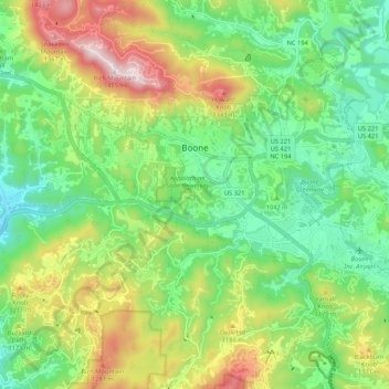
Name: Boone topographic map, elevation, terrain.
Location: Boone, Watauga County, North Carolina, United States (36.18640 -81.71645 36.23035 -81.61028)
Average elevation: 3,507 ft
Minimum elevation: 2,828 ft
Maximum elevation: 4,718 ft
Watauga County trails, hiking, mountain biking, running and outdoor activities
Other topographic maps
Click on a map to view its topography, its elevation and its terrain.
Valle Crucis
United States > North Carolina > Watauga County
Valle Crucis is located at the banks of Dutch Creek and Watauga River, at an elevation of 2,677 feet (816 m) above sea level. To its north and east is Tester Mountain and to its south and west is Valle Mountain. The community is also within the Pisgah National Forest boundary, which limits some development in…
Average elevation: 2,966 ft
Beech Mountain
United States > North Carolina > Watauga County > Beech Mountain
Average elevation: 4,147 ft
Laurel Park
United States > North Carolina > Watauga County > Blowing Rock
Average elevation: 3,159 ft
Rich Mountain
United States > North Carolina > Watauga County
Rich Mountain is a mountain located in the North Carolina High Country, roughly 3 miles (4.8 km) northwest of the town of Boone. Its elevation reaches 4,748 feet (1,447 m).
Average elevation: 3,983 ft
Buckeye Lake
United States > North Carolina > Watauga County > Beech Mountain
Average elevation: 3,806 ft
Elk Knob
United States > North Carolina > Watauga County
Elk Knob is a mountain in the North Carolina High Country, north of the community of Meat Camp. Its elevation reaches 5,538 feet (1,688 m).
Average elevation: 4,469 ft
Appalachian Ski Mountain Dam
United States > North Carolina > Watauga County
Average elevation: 3,652 ft
Rich Mountain
United States > North Carolina > Watauga County
Rich Mountain is a mountain located in the North Carolina High Country, roughly 3 miles (4.8 km) northwest of the town of Boone. Its elevation reaches 4,748 feet (1,447 m).
Average elevation: 3,983 ft
Boone
United States > North Carolina > Watauga County > Boone > Boone
Boone is located at 36°12′41″N 81°40′7″W / 36.21139°N 81.66861°W / 36.21139; -81.66861 (36.211364, −81.668657) and has an elevation of 3,333 feet (1015.9 m) above sea level. An earlier survey gave the elevation as 3,332 ft and since then it has been published as having an elevation of…
Average elevation: 3,205 ft