
Perkins topographic map
Click on the map to display elevation.
About this map
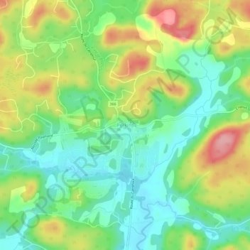
Name: Perkins topographic map, elevation, terrain.
Average elevation: 495 ft
Minimum elevation: 335 ft
Maximum elevation: 745 ft
Other topographic maps
Click on a map to view its topography, its elevation and its terrain.
Lac du Marbre
Canada > Quebec > Les Collines-de-l'Outaouais > Val-des-Monts
Average elevation: 1,004 ft
Lac Létourneau
Canada > Quebec > Les Collines-de-l'Outaouais > Val-des-Monts
Average elevation: 541 ft
Parc Nakkertok
Canada > Quebec > Les Collines-de-l'Outaouais > Val-des-Monts
Average elevation: 696 ft