
Make a donation
Gear up for your next adventure:
As an Amazon Associate, this site earns from qualifying purchases at no extra cost to you.
Parc Nakkertok topographic map
Click on the map to display elevation.
Make a donation
Gear up for your next adventure:
As an Amazon Associate, this site earns from qualifying purchases at no extra cost to you.
About this map
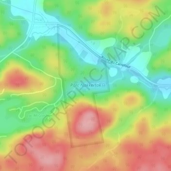
Name: Parc Nakkertok topographic map, elevation, terrain.
Average elevation: 696 ft
Minimum elevation: 492 ft
Maximum elevation: 935 ft
Make a donation
Gear up for your next adventure:
As an Amazon Associate, this site earns from qualifying purchases at no extra cost to you.
Other topographic maps
Click on a map to view its topography, its elevation and its terrain.
Lac Létourneau
Canada > Quebec > Les Collines-de-l'Outaouais > Val-des-Monts
Average elevation: 541 ft
Lac du Marbre
Canada > Quebec > Les Collines-de-l'Outaouais > Val-des-Monts
Average elevation: 1,004 ft
Saint-Pierre de Wakefield
Canada > Quebec > Les Collines-de-l'Outaouais > Val-des-Monts
Average elevation: 735 ft
Make a donation
Gear up for your next adventure:
As an Amazon Associate, this site earns from qualifying purchases at no extra cost to you.