Geolocate

Reichenbach topographic map

Click on the map to display elevation.

About this map

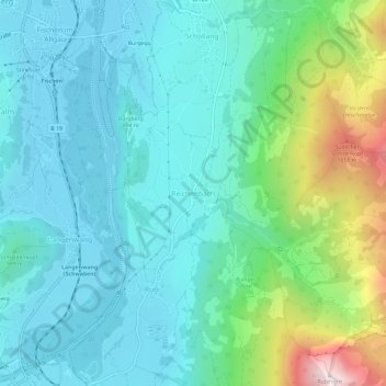
Name: Reichenbach topographic map, elevation, terrain.

Location: Reichenbach, Oberstdorf, Landkreis Oberallgäu, Bayern, 87561, Deutschland (47.42356 10.27342 47.46356 10.31342)

Average elevation: 3,301 ft

Minimum elevation: 2,477 ft

Maximum elevation: 6,302 ft

Other topographic maps

Click on a map to view its topography, its elevation and its terrain.

Stillachtal

Deutschland > Bayern > Landkreis Oberallgäu > Oberstdorf

Average elevation: 4,472 ft

Trettach

Deutschland > Bayern > Landkreis Oberallgäu > Oberstdorf

Average elevation: 4,820 ft

Schlappolt

Deutschland > Bayern > Landkreis Oberallgäu > Oberstdorf

Das 163,43 ha große Gebiet mit der Nr. NSG-00298.01 wurde im Jahr 1986 unter Naturschutz gestellt. Es ist in Bayern der einzige Flyschbereich, der nahezu die alpine Höhenstufe erreicht.

Average elevation: 5,207 ft

Gear up for your next adventure:

👟Trail Running Shoes - Lightweight shoes for trail runners
🧦Merino Wool Socks - Moisture-wicking, blister-preventing socks for long treks
🛰️Satellite Messengers - Emergency SOS and two-way messaging for off-grid adventures
🏔️Mountain Trail Maps - High‑detail maps for popular peaks
🦶Hiking Gaiters - Keep debris and water out of your boots

As an Amazon Associate, this site earns from qualifying purchases at no extra cost to you.