
Make a donation
Gear up for your next adventure:
As an Amazon Associate, this site earns from qualifying purchases at no extra cost to you.
Stillachtal topographic map
Click on the map to display elevation.
Make a donation
Gear up for your next adventure:
As an Amazon Associate, this site earns from qualifying purchases at no extra cost to you.
About this map
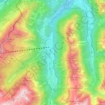
Name: Stillachtal topographic map, elevation, terrain.
Average elevation: 4,472 ft
Minimum elevation: 2,733 ft
Maximum elevation: 7,073 ft
Make a donation
Gear up for your next adventure:
As an Amazon Associate, this site earns from qualifying purchases at no extra cost to you.
Other topographic maps
Click on a map to view its topography, its elevation and its terrain.
Mädelegabel
Deutschland > Bayern > Landkreis Oberallgäu > Oberstdorf
Zusammen mit der niedrigeren Trettachspitze (2595 m ü. NHN) und der höheren Hochfrottspitze (2649 m ü. NHN) bildet die Mädelegabel das oft bewunderte Dreigestirn oberhalb von Einödsbach. Der Name stammt von Mähder (eine gemähte Bergwiese) in der Nähe; Gabel rührt vom Erscheinungsbild des Dreigestirns…
Average elevation: 6,870 ft
Nebelhorn
Deutschland > Bayern > Landkreis Oberallgäu > Oberstdorf
Die Schartenhöhe des Nebelhorns beträgt mindestens 24 Meter, seine Dominanz 500 Meter, wobei jeweils der Westliche Wengenkopf Referenzberg ist.
Average elevation: 5,879 ft
Sonnenkopf
Deutschland > Bayern > Landkreis Oberallgäu > Oberstdorf
Der Sonnenkopf ist ein 1712 m ü. NHN hoher Nebengipfel des Schnippenkopfs in den Allgäuer Alpen in der Nähe von Sonthofen in Bayern. Er ist Teil der Sonnenkopfgruppe, die parallel in Nord-Süd-Richtung zum höheren Großer-Daumen-Bergzug verläuft, der sich östlich befindet. Der Sonnenkopf besteht…
Average elevation: 4,593 ft
Tiefenbach
Deutschland > Bayern > Landkreis Oberallgäu > Oberstdorf > Tiefenbach
Average elevation: 3,186 ft
Make a donation
Gear up for your next adventure:
As an Amazon Associate, this site earns from qualifying purchases at no extra cost to you.
Schochen
Deutschland > Bayern > Landkreis Oberallgäu > Oberstdorf
Die Schartenhöhe des Schochens beträgt mindestens 60 Meter, seine Dominanz 800 Meter, wobei jeweils der Lachenkopf Referenzberg ist.
Average elevation: 5,390 ft
Make a donation
Gear up for your next adventure:
As an Amazon Associate, this site earns from qualifying purchases at no extra cost to you.
Make a donation
Gear up for your next adventure:
As an Amazon Associate, this site earns from qualifying purchases at no extra cost to you.
Make a donation
Gear up for your next adventure:
As an Amazon Associate, this site earns from qualifying purchases at no extra cost to you.
Gottenried
Deutschland > Bayern > Landkreis Oberallgäu > Oberstdorf > Gottenried
Average elevation: 4,226 ft
Mädelegabel
Deutschland > Bayern > Landkreis Oberallgäu > Oberstdorf
Zusammen mit der niedrigeren Trettachspitze (2595 m ü. NHN) und der höheren Hochfrottspitze (2649 m ü. NHN) bildet die Mädelegabel das oft bewunderte Dreigestirn oberhalb von Einödsbach. Der Name stammt von Mähder (eine gemähte Bergwiese) in der Nähe; Gabel rührt vom Erscheinungsbild des Dreigestirns…
Average elevation: 6,870 ft