Geolocate

South Freeport topographic map

Click on the map to display elevation.

About this map

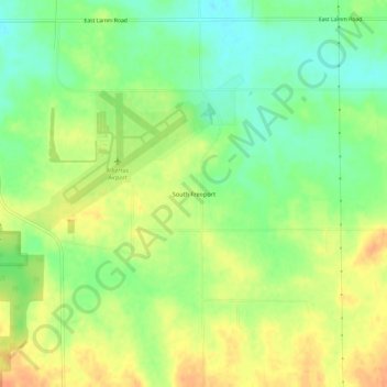
Name: South Freeport topographic map, elevation, terrain.

Location: South Freeport, Stephenson County, Illinois, United States (42.22086 -89.59261 42.26086 -89.55261)

Average elevation: 833 ft

Minimum elevation: 768 ft

Maximum elevation: 899 ft

Stephenson County trails, hiking, mountain biking, running and outdoor activities

Other topographic maps

Click on a map to view its topography, its elevation and its terrain.

Freeport

United States > Illinois > Stephenson County

Average elevation: 801 ft

Lena

United States > Illinois > Stephenson County

Average elevation: 915 ft

German Valley

United States > Illinois > Stephenson County

Average elevation: 840 ft

Freeport

United States > Illinois > Stephenson County

Average elevation: 801 ft

Cedarville

United States > Illinois > Stephenson County

Average elevation: 837 ft

Winslow

United States > Illinois > Stephenson County

Average elevation: 810 ft

Rock Run

United States > Illinois > Stephenson County > Rock Grove

Average elevation: 883 ft

Freeport

United States > Illinois > Stephenson County

Average elevation: 801 ft

Gear up for your next adventure:

🪶LED Camping Lantern - Bright lantern for camp lighting
🧢Outdoor Hiking Hat - Sun protection hat for outdoor explorers
🔭Telescopic Hiking Pole - Adjustable pole for hiking stability
🦶Carbon Trekking Poles - Reduce knee impact on steep descents with ultra-light poles
🪶Trail Camera - Capture wildlife on your hikes

As an Amazon Associate, this site earns from qualifying purchases at no extra cost to you.