Geolocate

Bluehole topographic map

Click on the map to display elevation.

About this map

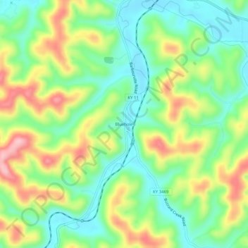
Name: Bluehole topographic map, elevation, terrain.

Location: Bluehole, Clay County, Kentucky, 40941, United States (37.08037 -83.77631 37.12037 -83.73631)

Average elevation: 1,060 ft

Minimum elevation: 823 ft

Maximum elevation: 1,434 ft

Clay County trails, hiking, mountain biking, running and outdoor activities

Other topographic maps

Click on a map to view its topography, its elevation and its terrain.

Manchester

United States > Kentucky > Clay County

Average elevation: 1,033 ft

Gear up for your next adventure:

🧣Hiking Neck Gaiter - Multi‑use neck protection for outdoor weather
🥾Hiking Shoes - Durable and comfortable shoes for trail hiking
📻Weather Alert Radios - Stay informed of storm risks while off-the-grid
🔪Outdoor Multitools - Essential survival tools for gear repair and field use
📷Action Cameras - Rugged cameras to document your journeys across rugged terrain

As an Amazon Associate, this site earns from qualifying purchases at no extra cost to you.