
Make a donation
Gear up for your next adventure:
As an Amazon Associate, this site earns from qualifying purchases at no extra cost to you.
Rocky Mountain House topographic map
Click on the map to display elevation.
Make a donation
Gear up for your next adventure:
As an Amazon Associate, this site earns from qualifying purchases at no extra cost to you.
Rocky Mountain House
Rocky Mountain House has a subarctic climate (Köppen climate classification Dfc) that borders on a humid continental climate (Köppen Dfb). Daytime temperatures are in general representative for the latter, but the larger diurnal temperature variation with the high elevation ensures frequent frosts. The January average high of around −4 °C (25 °F) is actually much milder than clear continental areas further east in Canada on similar and lower parallels.
Make a donation
Gear up for your next adventure:
As an Amazon Associate, this site earns from qualifying purchases at no extra cost to you.
About this map
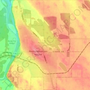
Name: Rocky Mountain House topographic map, elevation, terrain.
Location: Rocky Mountain House, Alberta, Canada (52.35580 -114.94816 52.40673 -114.87780)
Average elevation: 3,235 ft
Minimum elevation: 3,091 ft
Maximum elevation: 3,323 ft
Make a donation
Gear up for your next adventure:
As an Amazon Associate, this site earns from qualifying purchases at no extra cost to you.