
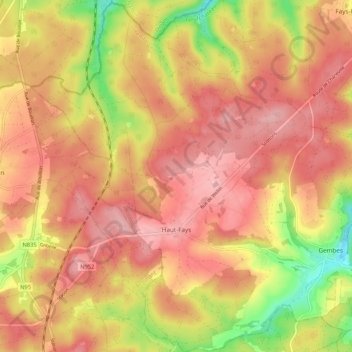
Haut-Fays topographic map
Interactive map
Click on the map to display elevation.
About this map
Name: Haut-Fays topographic map, elevation, terrain.
Average elevation: 1,266 ft
Minimum elevation: 925 ft
Maximum elevation: 1,467 ft
Other topographic maps
Click on a map to view its topography, its elevation and its terrain.
Porcheresse
Belgique > Luxembourg > Neufchâteau > Daverdisse
Porcheresse, Daverdisse, Neufchâteau, Luxembourg, Wallonie, Belgique
Average elevation: 1,171 ft
Vlessart
Belgique > Luxembourg > Neufchâteau
Vlessart, Léglise, Neufchâteau, Luxembourg, Wallonie, 6721, Belgique
Average elevation: 1,522 ft
6860
Belgique > Luxembourg > Neufchâteau > Léglise
6860, Anlier, Léglise, Neufchâteau, Luxembourg, Wallonie, Belgique
Average elevation: 1,558 ft
Gennevaux
Belgique > Luxembourg > Neufchâteau
Gennevaux, Léglise, Neufchâteau, Luxembourg, Wallonie, 6860, Belgique
Average elevation: 1,444 ft
Sohier
Belgique > Luxembourg > Neufchâteau
Sohier, Wellin, Neufchâteau, Luxembourg, Wallonie, Belgique
Average elevation: 909 ft
Offagne
Belgique > Luxembourg > Neufchâteau
Offagne, Paliseul, Neufchâteau, Luxembourg, Wallonie, Belgique
Average elevation: 1,362 ft
Molinfaing
Belgique > Luxembourg > Neufchâteau
Molinfaing, Longlier, Neufchâteau, Luxembourg, Wallonie, Belgique
Average elevation: 1,539 ft
Corbion
Belgique > Luxembourg > Neufchâteau > Bouillon
Corbion, Bouillon, Neufchâteau, Luxembourg, Wallonie, 6838, Belgique
Average elevation: 1,129 ft
Beauva
Belgique > Luxembourg > Neufchâteau > Bonnerue
Beauva, Bonnerue, Moircy, Libramont-Chevigny, Neufchâteau, Luxembourg, Wallonie, 6800, Belgique
Average elevation: 1,503 ft
Saint-Hubert
Belgique > Luxembourg > Neufchâteau
Saint-Hubert, Neufchâteau, Luxembourg, Wallonie, 6870, Belgique
Average elevation: 1,480 ft
Freux
Belgique > Luxembourg > Neufchâteau
Freux, Libramont-Chevigny, Neufchâteau, Luxembourg, Wallonie, Belgique
Average elevation: 1,565 ft
Bohème
Belgique > Luxembourg > Neufchâteau > Daverdisse
Bohème, Haut-Fays, Daverdisse, Neufchâteau, Luxembourg, Wallonie, 6929, Belgique
Average elevation: 1,348 ft
Neufchâteau
Belgique > Luxembourg > Neufchâteau
Neufchâteau, Luxembourg, Wallonie, 6840, Belgique
Average elevation: 1,434 ft
Traimont
Belgique > Luxembourg > Neufchâteau
Traimont, Léglise, Neufchâteau, Luxembourg, Wallonie, Belgique
Average elevation: 1,526 ft
Assenois
Belgique > Luxembourg > Neufchâteau
Assenois, Léglise, Neufchâteau, Luxembourg, Wallonie, Belgique
Average elevation: 1,368 ft
Le Tombeau du Géant
Belgique > Luxembourg > Neufchâteau > Bouillon > Ucimont > Botassart
Le Tombeau du Géant, Moulin du Rivage, Botassart, Ucimont, Bouillon, Neufchâteau, Luxembourg, Wallonie, 6833, Belgique
Average elevation: 984 ft
Hatrival
Belgique > Luxembourg > Neufchâteau
Hatrival, Saint-Hubert, Neufchâteau, Luxembourg, Wallonie, Belgique
Average elevation: 1,460 ft
Remagne
Belgique > Luxembourg > Neufchâteau
Remagne, Libramont-Chevigny, Neufchâteau, Luxembourg, Wallonie, Belgique
Average elevation: 1,575 ft
Sensenruth
Belgique > Luxembourg > Neufchâteau > Bouillon
Sensenruth, Bouillon, Neufchâteau, Luxembourg, Wallonie, 6832, Belgique
Average elevation: 1,175 ft
Bouillon
Belgique > Luxembourg > Neufchâteau > Bouillon
Bouillon, Neufchâteau, Luxembourg, Wallonie, 6830, Belgique
Average elevation: 1,109 ft
Louftémont
Belgique > Luxembourg > Neufchâteau > Louftémont
Louftémont, Léglise, Neufchâteau, Luxembourg, Wallonie, 6721, Belgique
Average elevation: 1,476 ft
Auby-sur-Semois
Belgique > Luxembourg > Neufchâteau > Auby-sur-Semois
Auby-sur-Semois, Bertrix, Neufchâteau, Luxembourg, Wallonie, Belgique
Average elevation: 1,138 ft
Longlier
Belgique > Luxembourg > Neufchâteau
Longlier, Neufchâteau, Luxembourg, Wallonie, Belgique
Average elevation: 1,532 ft
Frahan
Belgique > Luxembourg > Neufchâteau > Bouillon > Rochehaut
Frahan, Rochehaut, Bouillon, Neufchâteau, Luxembourg, Wallonie, 6838, Belgique
Average elevation: 955 ft
Bouillon
Belgique > Luxembourg > Neufchâteau
Bouillon, Neufchâteau, Luxembourg, Wallonie, Belgique
Average elevation: 1,122 ft
Ebly
Belgique > Luxembourg > Neufchâteau
Ebly, Léglise, Neufchâteau, Luxembourg, Wallonie, Belgique
Average elevation: 1,542 ft
Bertrix
Belgique > Luxembourg > Neufchâteau
Bertrix, Neufchâteau, Luxembourg, Wallonie, 6880, Belgique
Average elevation: 1,322 ft
Mellier
Belgique > Luxembourg > Neufchâteau > Léglise
Mellier, Léglise, Neufchâteau, Luxembourg, Wallonie, 6860, Belgique
Average elevation: 1,404 ft
Rochehaut
Belgique > Luxembourg > Neufchâteau > Bouillon
Rochehaut, Bouillon, Neufchâteau, Luxembourg, Wallonie, Belgique
Average elevation: 971 ft
Ochamps
Belgique > Luxembourg > Neufchâteau
Ochamps, Libin, Neufchâteau, Luxembourg, Wallonie, Belgique
Average elevation: 1,460 ft
Opont
Belgique > Luxembourg > Neufchâteau
Opont, Paliseul, Neufchâteau, Luxembourg, Wallonie, 6852, Belgique
Average elevation: 1,237 ft
Chanly
Belgique > Luxembourg > Neufchâteau > Chanly
Chanly, Wellin, Neufchâteau, Luxembourg, Wallonie, 6921, Belgique
Average elevation: 906 ft
Hamaide
Belgique > Luxembourg > Neufchâteau > Redu
Hamaide, Redu, Libin, Neufchâteau, Luxembourg, Wallonie, Belgique
Average elevation: 1,257 ft
Maissin
Belgique > Luxembourg > Neufchâteau
Maissin, Paliseul, Neufchâteau, Luxembourg, Wallonie, Belgique
Average elevation: 1,237 ft
Redu
Belgique > Luxembourg > Neufchâteau > Libin
Redu, Libin, Neufchâteau, Luxembourg, Wallonie, Belgique
Average elevation: 1,188 ft
Tronquoy
Belgique > Luxembourg > Neufchâteau
Tronquoy, Longlier, Neufchâteau, Luxembourg, Wallonie, 6840, Belgique
Average elevation: 1,562 ft
Petitvoir
Belgique > Luxembourg > Neufchâteau
Petitvoir, Tournay, Neufchâteau, Luxembourg, Wallonie, Belgique
Average elevation: 1,319 ft
Dohan
Belgique > Luxembourg > Neufchâteau > Bouillon
Dohan, Bouillon, Neufchâteau, Luxembourg, Wallonie, Belgique
Average elevation: 932 ft
Mirwart
Belgique > Luxembourg > Neufchâteau
Mirwart, Saint-Hubert, Neufchâteau, Luxembourg, Wallonie, Belgique
Average elevation: 1,178 ft
Wideumont
Belgique > Luxembourg > Neufchâteau > Saint-Marie-Chevigny
Wideumont, Saint-Marie-Chevigny, Libramont-Chevigny, Neufchâteau, Luxembourg, Wallonie, Belgique
Average elevation: 1,634 ft
Wellin
Belgique > Luxembourg > Neufchâteau
Wellin, Neufchâteau, Luxembourg, Wallonie, Belgique
Average elevation: 928 ft
Léglise
Belgique > Luxembourg > Neufchâteau
Léglise, Neufchâteau, Luxembourg, Wallonie, 6860, Belgique
Average elevation: 1,447 ft
Cordemois
Belgique > Luxembourg > Neufchâteau > Bouillon
Cordemois, Bouillon, Neufchâteau, Luxembourg, Wallonie, 6830, Belgique
Average elevation: 1,024 ft
Paliseul
Belgique > Luxembourg > Neufchâteau
Paliseul, Neufchâteau, Luxembourg, Wallonie, Belgique
Average elevation: 1,289 ft
Curfoz
Belgique > Luxembourg > Neufchâteau > Bouillon
Curfoz, Bouillon, Neufchâteau, Luxembourg, Wallonie, 6831, Belgique
Average elevation: 1,129 ft
Hurtebise
Belgique > Luxembourg > Neufchâteau > Saint-Hubert > Hurtebise
Hurtebise, Saint-Hubert, Neufchâteau, Luxembourg, Wallonie, Belgique
Average elevation: 1,709 ft
Lesse
Belgique > Luxembourg > Neufchâteau
Lesse, Libin, Neufchâteau, Luxembourg, Wallonie, Belgique
Average elevation: 1,142 ft
Herbeumont
Belgique > Luxembourg > Neufchâteau
Herbeumont, Neufchâteau, Luxembourg, Wallonie, 6887, Belgique
Average elevation: 1,224 ft
Briahan
Belgique > Luxembourg > Neufchâteau > Bouillon
Briahan, Sensenruth, Bouillon, Neufchâteau, Luxembourg, Wallonie, 6832, Belgique
Average elevation: 1,191 ft
Libin
Belgique > Luxembourg > Neufchâteau
Libin, Neufchâteau, Luxembourg, Wallonie, 6890, Belgique
Average elevation: 1,368 ft