Geolocate

Fort Collins topographic map

Click on the map to display elevation.

About this map

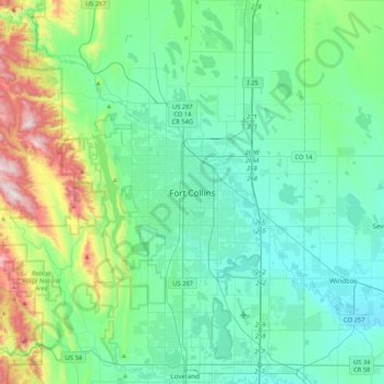
Name: Fort Collins topographic map, elevation, terrain.

Location: Fort Collins, Larimer County, Colorado, 80525-2227, United States (40.39085 -105.22681 40.71085 -104.90681)

Average elevation: 5,312 ft

Minimum elevation: 4,731 ft

Maximum elevation: 7,677 ft

Larimer County trails, hiking, mountain biking, running and outdoor activities

Other topographic maps

Click on a map to view its topography, its elevation and its terrain.

Gear up for your next adventure:

🦶Carbon Trekking Poles - Reduce knee impact on steep descents with ultra-light poles
🧤Tactile Hiking Gloves - Keep hands warm while operating GPS and smartphone screens
🪶Fire Starter Kit - Reliable fire starter for survival and camping
🎒Hydration Pack - Hands‑free water reservoir for long hikes
Backpacking Tents - Weight-optimized shelters for multi-day topographic surveys

As an Amazon Associate, this site earns from qualifying purchases at no extra cost to you.