
Make a donation
Gear up for your next adventure:
As an Amazon Associate, this site earns from qualifying purchases at no extra cost to you.
Outer Nanaimo Harbour topographic map
Click on the map to display elevation.
Make a donation
Gear up for your next adventure:
As an Amazon Associate, this site earns from qualifying purchases at no extra cost to you.
About this map
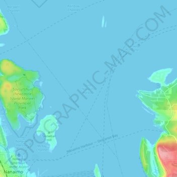
Name: Outer Nanaimo Harbour topographic map, elevation, terrain.
Average elevation: 23 ft
Minimum elevation: -3 ft
Maximum elevation: 361 ft
Make a donation
Gear up for your next adventure:
As an Amazon Associate, this site earns from qualifying purchases at no extra cost to you.
Other topographic maps
Click on a map to view its topography, its elevation and its terrain.
Cathers Lake
Canada > British Columbia > Regional District of Nanaimo > Nanaimo
Average elevation: 390 ft
Lost Lake
Canada > British Columbia > Regional District of Nanaimo > Nanaimo
Average elevation: 358 ft
East Wellington Park
Canada > British Columbia > Regional District of Nanaimo > Nanaimo
Average elevation: 325 ft
Colinwood Park
Canada > British Columbia > Regional District of Nanaimo > Nanaimo
Average elevation: 341 ft
Make a donation
Gear up for your next adventure:
As an Amazon Associate, this site earns from qualifying purchases at no extra cost to you.