
Make a donation
Gear up for your next adventure:
As an Amazon Associate, this site earns from qualifying purchases at no extra cost to you.
Port Bruce topographic map
Click on the map to display elevation.
Make a donation
Gear up for your next adventure:
As an Amazon Associate, this site earns from qualifying purchases at no extra cost to you.
About this map
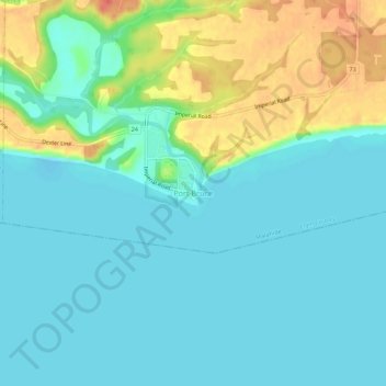
Name: Port Bruce topographic map, elevation, terrain.
Location: Port Bruce, Elgin County, Ontario, N5H 2R4, Canada (42.63433 -81.02882 42.67433 -80.98882)
Average elevation: 607 ft
Minimum elevation: 558 ft
Maximum elevation: 735 ft
Make a donation
Gear up for your next adventure:
As an Amazon Associate, this site earns from qualifying purchases at no extra cost to you.
Other topographic maps
Click on a map to view its topography, its elevation and its terrain.
John E. Pearce Provincial Park
Canada > Ontario > Elgin County > Dutton/Dunwich
Average elevation: 656 ft
Make a donation
Gear up for your next adventure:
As an Amazon Associate, this site earns from qualifying purchases at no extra cost to you.