
Make a donation
Gear up for your next adventure:
As an Amazon Associate, this site earns from qualifying purchases at no extra cost to you.
Dendermonde topographic map
Click on the map to display elevation.
Make a donation
Gear up for your next adventure:
As an Amazon Associate, this site earns from qualifying purchases at no extra cost to you.
Dendermonde
Dendermonde heeft een omvangrijk bouwkundig erfgoed. Hoogtepunten zijn de Lakenhalle (Stadhuis) en het Vleeshuis (Vleeshuismuseum) op de Grote Markt. Andere historische gebouwen zijn de Onze-Lieve-Vrouwekerk en de Hollandse Kazerne.
Make a donation
Gear up for your next adventure:
As an Amazon Associate, this site earns from qualifying purchases at no extra cost to you.
About this map
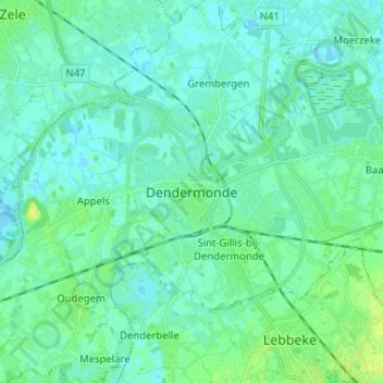
Name: Dendermonde topographic map, elevation, terrain.
Location: Dendermonde, Oost-Vlaanderen, Vlaanderen, 9200, België (50.99123 4.05811 51.07123 4.13811)
Average elevation: 13 ft
Minimum elevation: -7 ft
Maximum elevation: 46 ft
Make a donation
Gear up for your next adventure:
As an Amazon Associate, this site earns from qualifying purchases at no extra cost to you.
Other topographic maps
Click on a map to view its topography, its elevation and its terrain.
Schoonaarde
België > Oost-Vlaanderen > Dendermonde > Dendermonde
Schoonaarde ligt aan de Schelde op een hoogte van 8-9 meter. De bodem is zandig en zandlemig.
Average elevation: 20 ft
Sint-Gillis-bij-Dendermonde
België > Oost-Vlaanderen > Dendermonde > Dendermonde
Sint-Gilles-bij-Dendermonde ligt aan de Dender. De zuidgrens van het grondgebied wordt gevormd door de Vondelbeek. Het sterk verstedelijkte grondgebied behoort tot Zandig Vlaanderen en de hoogte bedraagt 4-8 meter.
Average elevation: 13 ft
Make a donation
Gear up for your next adventure:
As an Amazon Associate, this site earns from qualifying purchases at no extra cost to you.
Camille Marchantplein
België > Oost-Vlaanderen > Dendermonde > Dendermonde > Sint-Gillis-bij-Dendermonde > Klein-Parijs
Average elevation: 16 ft