
Make a donation
Gear up for your next adventure:
As an Amazon Associate, this site earns from qualifying purchases at no extra cost to you.
Uyumbicho topographic map
Click on the map to display elevation.
Make a donation
Gear up for your next adventure:
As an Amazon Associate, this site earns from qualifying purchases at no extra cost to you.
About this map
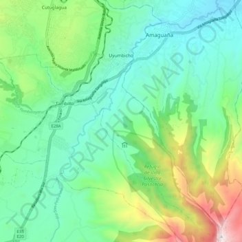
Name: Uyumbicho topographic map, elevation, terrain.
Location: Uyumbicho, Machachi, Pichincha, 171109, Ecuador (-0.46257 -78.55230 -0.36224 -78.48017)
Average elevation: 9,642 ft
Minimum elevation: 8,238 ft
Maximum elevation: 13,484 ft
Make a donation
Gear up for your next adventure:
As an Amazon Associate, this site earns from qualifying purchases at no extra cost to you.
Other topographic maps
Click on a map to view its topography, its elevation and its terrain.
Cotopaxi
Ecuador > Pichincha > Machachi > Machachi
El Cotopaxi (pronunciado [ko.toˈpak.si]) es un estratovolcán activo que se encuentra en la ciudad de Latacunga, Provincia de Cotopaxi, República del Ecuador. Con una elevación de 5897 m s. n. m., es el segundo volcán más alto del país —sólo superado por el Chimborazo. Está situado a 33 km al noreste…
Average elevation: 17,434 ft
Make a donation
Gear up for your next adventure:
As an Amazon Associate, this site earns from qualifying purchases at no extra cost to you.