
Make a donation
Gear up for your next adventure:
As an Amazon Associate, this site earns from qualifying purchases at no extra cost to you.
New Haven County topographic map
Click on the map to display elevation.
Make a donation
Gear up for your next adventure:
As an Amazon Associate, this site earns from qualifying purchases at no extra cost to you.
New Haven County
The terrain is mostly flat near the coast, with low hills defining the rest of the area, rising significantly only in the north of the county. The highest elevation is close to the northernmost point in the county, found at two areas of approximately 1,050 feet (320 m) above sea level in the town of Wolcott. The lowest point is sea level.
Make a donation
Gear up for your next adventure:
As an Amazon Associate, this site earns from qualifying purchases at no extra cost to you.
About this map
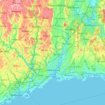
Name: New Haven County topographic map, elevation, terrain.
Average elevation: 285 ft
Minimum elevation: -13 ft
Maximum elevation: 1,220 ft
Make a donation
Gear up for your next adventure:
As an Amazon Associate, this site earns from qualifying purchases at no extra cost to you.
Other topographic maps
Click on a map to view its topography, its elevation and its terrain.
South End Point
United States > Connecticut > South Central Connecticut Planning Region > East Haven > Momauguin
Average elevation: 7 ft
Sea Bluff
United States > Connecticut > South Central Connecticut Planning Region > West Haven > West Shore
Average elevation: 46 ft
Killingworth Court
United States > Connecticut > South Central Connecticut Planning Region > New Haven
Average elevation: 43 ft
Hein Trails
United States > Connecticut > South Central Connecticut Planning Region > Bethany > Davidsons Corner
Average elevation: 574 ft
Make a donation
Gear up for your next adventure:
As an Amazon Associate, this site earns from qualifying purchases at no extra cost to you.
Indian Neck
United States > Connecticut > South Central Connecticut Planning Region > Branford
Average elevation: 13 ft
Northford
United States > Connecticut > South Central Connecticut Planning Region > North Branford
Average elevation: 233 ft
Ansonia
United States > Connecticut > South Central Connecticut Planning Region
Average elevation: 364 ft
Derby
United States > Connecticut > South Central Connecticut Planning Region
According to the United States Census Bureau, the town has a total area of 5.4 square miles (8.7 km2), of which, 5.0 square miles (13 km2) is land and 0.4 square miles (1.0 km2) (7.41%) is water. The city is home to the 417 acres (0.652 sq mi) Osbornedale State Park. Derby is divided into two main sections by…
Average elevation: 259 ft
Make a donation
Gear up for your next adventure:
As an Amazon Associate, this site earns from qualifying purchases at no extra cost to you.
Momauguin
United States > Connecticut > South Central Connecticut Planning Region > East Haven
Average elevation: 10 ft
Indian Cave
United States > Connecticut > South Central Connecticut Planning Region > Guilford
Average elevation: 82 ft
North Madison
United States > Connecticut > South Central Connecticut Planning Region > Madison
Average elevation: 299 ft
Nut Plains
United States > Connecticut > South Central Connecticut Planning Region > Guilford
Average elevation: 115 ft
Make a donation
Gear up for your next adventure:
As an Amazon Associate, this site earns from qualifying purchases at no extra cost to you.
Fort Trumbull
United States > Connecticut > South Central Connecticut Planning Region > Milford
Average elevation: 23 ft
Lake Whitney
United States > Connecticut > South Central Connecticut Planning Region > Hamden
Average elevation: 82 ft
Branford Court
United States > Connecticut > South Central Connecticut Planning Region > New Haven
Average elevation: 43 ft
West Shore
United States > Connecticut > South Central Connecticut Planning Region > West Haven
Average elevation: 30 ft
Make a donation
Gear up for your next adventure:
As an Amazon Associate, this site earns from qualifying purchases at no extra cost to you.
North Haven Bridge
United States > Connecticut > South Central Connecticut Planning Region > North Haven
Average elevation: 72 ft
Lake Whitney
United States > Connecticut > South Central Connecticut Planning Region > Hamden > Whitneyville
Average elevation: 82 ft
Branford Hills
United States > Connecticut > South Central Connecticut Planning Region > Branford
Average elevation: 39 ft
East Peak
United States > Connecticut > South Central Connecticut Planning Region > Meriden
Average elevation: 505 ft
Make a donation
Gear up for your next adventure:
As an Amazon Associate, this site earns from qualifying purchases at no extra cost to you.
Silver Beach
United States > Connecticut > South Central Connecticut Planning Region > Milford > Fort Trumbull
Average elevation: 16 ft
Silver Beach
United States > Connecticut > South Central Connecticut Planning Region > Milford
Average elevation: 16 ft
Nut Plains
United States > Connecticut > South Central Connecticut Planning Region > Guilford
Average elevation: 115 ft
South Meriden
United States > Connecticut > South Central Connecticut Planning Region > Meriden
Average elevation: 180 ft
Make a donation
Gear up for your next adventure:
As an Amazon Associate, this site earns from qualifying purchases at no extra cost to you.
Bayview
United States > Connecticut > South Central Connecticut Planning Region > Milford
Average elevation: 16 ft
Brightview
United States > Connecticut > South Central Connecticut Planning Region > New Haven
Average elevation: 16 ft
Fort Trumbull
United States > Connecticut > South Central Connecticut Planning Region > Milford
Average elevation: 23 ft
Forest Heights
United States > Connecticut > South Central Connecticut Planning Region > Milford
Average elevation: 62 ft
Make a donation
Gear up for your next adventure:
As an Amazon Associate, this site earns from qualifying purchases at no extra cost to you.
Sea Bluff
United States > Connecticut > South Central Connecticut Planning Region > West Haven > West Shore
Average elevation: 46 ft
Momauguin
United States > Connecticut > South Central Connecticut Planning Region > East Haven
Average elevation: 10 ft
Mount Carmel Center
United States > Connecticut > South Central Connecticut Planning Region > Hamden
Average elevation: 259 ft
Morningside
United States > Connecticut > South Central Connecticut Planning Region > Milford
Average elevation: 16 ft
Make a donation
Gear up for your next adventure:
As an Amazon Associate, this site earns from qualifying purchases at no extra cost to you.
East River
United States > Connecticut > South Central Connecticut Planning Region > Madison
Average elevation: 30 ft
Big Indian
United States > Connecticut > South Central Connecticut Planning Region > Guilford
Average elevation: 135 ft
Sunset Hill
United States > Connecticut > South Central Connecticut Planning Region > Branford
Average elevation: 39 ft
Sea Bluff
United States > Connecticut > South Central Connecticut Planning Region > West Haven > West Shore
Average elevation: 46 ft
Make a donation
Gear up for your next adventure:
As an Amazon Associate, this site earns from qualifying purchases at no extra cost to you.
Clark Hill
United States > Connecticut > South Central Connecticut Planning Region > Milford
Average elevation: 36 ft
Peter's Rock
United States > Connecticut > South Central Connecticut Planning Region > North Haven
Average elevation: 125 ft
Quinnipiac
United States > Connecticut > South Central Connecticut Planning Region > Wallingford
Average elevation: 102 ft
North Branford Town Green
United States > Connecticut > South Central Connecticut Planning Region > North Branford
Average elevation: 144 ft
Make a donation
Gear up for your next adventure:
As an Amazon Associate, this site earns from qualifying purchases at no extra cost to you.
Fair Haven East
United States > Connecticut > South Central Connecticut Planning Region > New Haven
Average elevation: 46 ft
Allingtown
United States > Connecticut > South Central Connecticut Planning Region > West Haven
Average elevation: 85 ft