
Make a donation
Gear up for your next adventure:
As an Amazon Associate, this site earns from qualifying purchases at no extra cost to you.
Ansonia topographic map
Click on the map to display elevation.
Make a donation
Gear up for your next adventure:
As an Amazon Associate, this site earns from qualifying purchases at no extra cost to you.
About this map
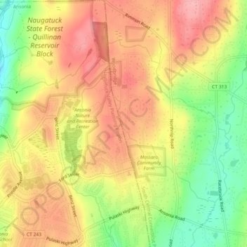
Name: Ansonia topographic map, elevation, terrain.
Average elevation: 364 ft
Minimum elevation: 141 ft
Maximum elevation: 531 ft
Make a donation
Gear up for your next adventure:
As an Amazon Associate, this site earns from qualifying purchases at no extra cost to you.
Other topographic maps
Click on a map to view its topography, its elevation and its terrain.
Guilford
United States > Connecticut > South Central Connecticut Planning Region
Average elevation: 203 ft
Wallingford
United States > Connecticut > South Central Connecticut Planning Region
Average elevation: 236 ft
New Haven
United States > Connecticut > South Central Connecticut Planning Region
Average elevation: 66 ft
Hamden
United States > Connecticut > South Central Connecticut Planning Region
Average elevation: 210 ft
Make a donation
Gear up for your next adventure:
As an Amazon Associate, this site earns from qualifying purchases at no extra cost to you.
North Haven
United States > Connecticut > South Central Connecticut Planning Region
Average elevation: 125 ft
Sea Bluff
United States > Connecticut > South Central Connecticut Planning Region > West Haven > West Shore
Average elevation: 46 ft
Meriden
United States > Connecticut > South Central Connecticut Planning Region
Average elevation: 289 ft
New Haven County
United States > Connecticut > South Central Connecticut Planning Region
The terrain is mostly flat near the coast, with low hills defining the rest of the area, rising significantly only in the north of the county. The highest elevation is close to the northernmost point in the county, found at two areas of approximately 1,050 feet (320 m) above sea level in the town of Wolcott.…
Average elevation: 285 ft
Make a donation
Gear up for your next adventure:
As an Amazon Associate, this site earns from qualifying purchases at no extra cost to you.
Bethany
United States > Connecticut > South Central Connecticut Planning Region
Average elevation: 531 ft
Indian Neck
United States > Connecticut > South Central Connecticut Planning Region > Branford
Average elevation: 13 ft
Madison
United States > Connecticut > South Central Connecticut Planning Region
Average elevation: 226 ft
Woodbridge
United States > Connecticut > South Central Connecticut Planning Region
Average elevation: 315 ft
Make a donation
Gear up for your next adventure:
As an Amazon Associate, this site earns from qualifying purchases at no extra cost to you.
Northford
United States > Connecticut > South Central Connecticut Planning Region > North Branford
Average elevation: 233 ft
Milford
United States > Connecticut > South Central Connecticut Planning Region
Average elevation: 59 ft
North Branford
United States > Connecticut > South Central Connecticut Planning Region
Average elevation: 223 ft
Orange
United States > Connecticut > South Central Connecticut Planning Region
Average elevation: 154 ft
Make a donation
Gear up for your next adventure:
As an Amazon Associate, this site earns from qualifying purchases at no extra cost to you.
West Haven
United States > Connecticut > South Central Connecticut Planning Region
Average elevation: 52 ft
Borough of Woodmont
United States > Connecticut > South Central Connecticut Planning Region > Milford
A majority of the borough land mass is safely above sea level. However, it does have a few low elevation areas which are subject to flooding during very heavy storm situations (Hurricanes). The most recent, circa 2013 FEMA generated flood map is shown at the right, with the borough border roughly outlined in…
Average elevation: 10 ft
Momauguin
United States > Connecticut > South Central Connecticut Planning Region > East Haven
Average elevation: 10 ft
Indian Cave
United States > Connecticut > South Central Connecticut Planning Region > Guilford
Average elevation: 82 ft
Make a donation
Gear up for your next adventure:
As an Amazon Associate, this site earns from qualifying purchases at no extra cost to you.
North Madison
United States > Connecticut > South Central Connecticut Planning Region > Madison
Average elevation: 299 ft
Nut Plains
United States > Connecticut > South Central Connecticut Planning Region > Guilford
Average elevation: 115 ft
Fort Trumbull
United States > Connecticut > South Central Connecticut Planning Region > Milford
Average elevation: 23 ft
Guilford
United States > Connecticut > South Central Connecticut Planning Region
Average elevation: 203 ft
Make a donation
Gear up for your next adventure:
As an Amazon Associate, this site earns from qualifying purchases at no extra cost to you.
Branford
United States > Connecticut > South Central Connecticut Planning Region
Average elevation: 56 ft
West Shore
United States > Connecticut > South Central Connecticut Planning Region > West Haven
Average elevation: 30 ft
North Haven Bridge
United States > Connecticut > South Central Connecticut Planning Region > North Haven
Average elevation: 72 ft
Sleeping Giant State Park
United States > Connecticut > South Central Connecticut Planning Region > Hamden
Sleeping Giant (also known as the Blue Hills and Mount Carmel), (Hobbomock in Quinnipiac), is a rugged traprock mountain with a high point of 739 feet (225 m), located eight miles (13 km) north of New Haven, Connecticut. A prominent landscape feature visible for miles, the Sleeping Giant receives its name from…
Average elevation: 259 ft
Make a donation
Gear up for your next adventure:
As an Amazon Associate, this site earns from qualifying purchases at no extra cost to you.
Hamden
United States > Connecticut > South Central Connecticut Planning Region
Average elevation: 210 ft
Meriden
United States > Connecticut > South Central Connecticut Planning Region
Average elevation: 289 ft
South End Point
United States > Connecticut > South Central Connecticut Planning Region > East Haven > Momauguin
Average elevation: 7 ft
West Haven
United States > Connecticut > South Central Connecticut Planning Region
Average elevation: 52 ft
Make a donation
Gear up for your next adventure:
As an Amazon Associate, this site earns from qualifying purchases at no extra cost to you.
Forest Heights
United States > Connecticut > South Central Connecticut Planning Region > Milford
Average elevation: 62 ft
New Haven
United States > Connecticut > South Central Connecticut Planning Region
Average elevation: 66 ft
Silver Beach
United States > Connecticut > South Central Connecticut Planning Region > Milford > Fort Trumbull
Average elevation: 16 ft
Branford Hills
United States > Connecticut > South Central Connecticut Planning Region > Branford
Average elevation: 39 ft
Make a donation
Gear up for your next adventure:
As an Amazon Associate, this site earns from qualifying purchases at no extra cost to you.
North Haven
United States > Connecticut > South Central Connecticut Planning Region
Average elevation: 125 ft
East Peak
United States > Connecticut > South Central Connecticut Planning Region > Meriden
Average elevation: 505 ft
New Haven
United States > Connecticut > South Central Connecticut Planning Region
Average elevation: 66 ft
New Haven County
United States > Connecticut > South Central Connecticut Planning Region
The terrain is mostly flat near the coast, with low hills defining the rest of the area, rising significantly only in the north of the county. The highest elevation is close to the northernmost point in the county, found at two areas of approximately 1,050 feet (320 m) above sea level in the town of Wolcott.…
Average elevation: 285 ft
Make a donation
Gear up for your next adventure:
As an Amazon Associate, this site earns from qualifying purchases at no extra cost to you.
New Haven
United States > Connecticut > South Central Connecticut Planning Region
Average elevation: 66 ft
West Haven
United States > Connecticut > South Central Connecticut Planning Region
Average elevation: 52 ft
Momauguin
United States > Connecticut > South Central Connecticut Planning Region > East Haven
Average elevation: 10 ft
Silver Beach
United States > Connecticut > South Central Connecticut Planning Region > Milford
Average elevation: 16 ft
Make a donation
Gear up for your next adventure:
As an Amazon Associate, this site earns from qualifying purchases at no extra cost to you.
Nut Plains
United States > Connecticut > South Central Connecticut Planning Region > Guilford
Average elevation: 115 ft
Woodbridge
United States > Connecticut > South Central Connecticut Planning Region
Average elevation: 315 ft
Milford
United States > Connecticut > South Central Connecticut Planning Region
Average elevation: 59 ft
Wallingford
United States > Connecticut > South Central Connecticut Planning Region
Average elevation: 236 ft
Make a donation
Gear up for your next adventure:
As an Amazon Associate, this site earns from qualifying purchases at no extra cost to you.
South Meriden
United States > Connecticut > South Central Connecticut Planning Region > Meriden
Average elevation: 180 ft
Bayview
United States > Connecticut > South Central Connecticut Planning Region > Milford
Average elevation: 16 ft
Bethany
United States > Connecticut > South Central Connecticut Planning Region
Average elevation: 531 ft
Brightview
United States > Connecticut > South Central Connecticut Planning Region > New Haven
Average elevation: 16 ft
Make a donation
Gear up for your next adventure:
As an Amazon Associate, this site earns from qualifying purchases at no extra cost to you.
Fort Trumbull
United States > Connecticut > South Central Connecticut Planning Region > Milford
Average elevation: 23 ft
Orange
United States > Connecticut > South Central Connecticut Planning Region
Average elevation: 154 ft
Sea Bluff
United States > Connecticut > South Central Connecticut Planning Region > West Haven > West Shore
Average elevation: 46 ft
Mount Carmel Center
United States > Connecticut > South Central Connecticut Planning Region > Hamden
Average elevation: 259 ft
Make a donation
Gear up for your next adventure:
As an Amazon Associate, this site earns from qualifying purchases at no extra cost to you.
Morningside
United States > Connecticut > South Central Connecticut Planning Region > Milford
Average elevation: 16 ft
Milford
United States > Connecticut > South Central Connecticut Planning Region
Average elevation: 59 ft
East River
United States > Connecticut > South Central Connecticut Planning Region > Madison
Average elevation: 30 ft
Big Indian
United States > Connecticut > South Central Connecticut Planning Region > Guilford
Average elevation: 135 ft
Make a donation
Gear up for your next adventure:
As an Amazon Associate, this site earns from qualifying purchases at no extra cost to you.
Sunset Hill
United States > Connecticut > South Central Connecticut Planning Region > Branford
Average elevation: 39 ft
Sea Bluff
United States > Connecticut > South Central Connecticut Planning Region > West Haven > West Shore
Average elevation: 46 ft
Clark Hill
United States > Connecticut > South Central Connecticut Planning Region > Milford
Average elevation: 36 ft
Peter's Rock
United States > Connecticut > South Central Connecticut Planning Region > North Haven
Average elevation: 125 ft
Make a donation
Gear up for your next adventure:
As an Amazon Associate, this site earns from qualifying purchases at no extra cost to you.
West Haven
United States > Connecticut > South Central Connecticut Planning Region
Average elevation: 52 ft
Quinnipiac
United States > Connecticut > South Central Connecticut Planning Region > Wallingford
Average elevation: 102 ft
Milford
United States > Connecticut > South Central Connecticut Planning Region
Average elevation: 59 ft
Branford
United States > Connecticut > South Central Connecticut Planning Region
Average elevation: 56 ft
Make a donation
Gear up for your next adventure:
As an Amazon Associate, this site earns from qualifying purchases at no extra cost to you.
Fair Haven East
United States > Connecticut > South Central Connecticut Planning Region > New Haven
Average elevation: 46 ft
New Haven
United States > Connecticut > South Central Connecticut Planning Region
Average elevation: 66 ft
North Branford
United States > Connecticut > South Central Connecticut Planning Region
Average elevation: 223 ft
Allingtown
United States > Connecticut > South Central Connecticut Planning Region > West Haven
Average elevation: 85 ft
Make a donation
Gear up for your next adventure:
As an Amazon Associate, this site earns from qualifying purchases at no extra cost to you.
Meriden
United States > Connecticut > South Central Connecticut Planning Region
Average elevation: 302 ft
Milford
United States > Connecticut > South Central Connecticut Planning Region
Average elevation: 59 ft
Milford
United States > Connecticut > South Central Connecticut Planning Region
Average elevation: 59 ft
New Haven
United States > Connecticut > South Central Connecticut Planning Region
Average elevation: 66 ft
Make a donation
Gear up for your next adventure:
As an Amazon Associate, this site earns from qualifying purchases at no extra cost to you.