
Make a donation
Gear up for your next adventure:
As an Amazon Associate, this site earns from qualifying purchases at no extra cost to you.
Wing Lake topographic map
Click on the map to display elevation.
Make a donation
Gear up for your next adventure:
As an Amazon Associate, this site earns from qualifying purchases at no extra cost to you.
About this map
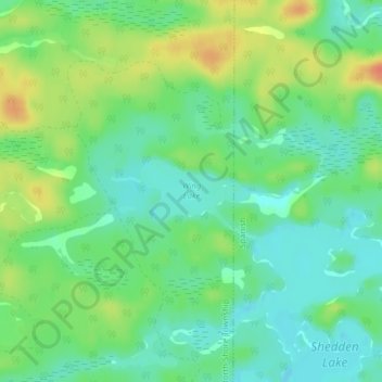
Name: Wing Lake topographic map, elevation, terrain.
Average elevation: 817 ft
Minimum elevation: 761 ft
Maximum elevation: 909 ft
Make a donation
Gear up for your next adventure:
As an Amazon Associate, this site earns from qualifying purchases at no extra cost to you.
Other topographic maps
Click on a map to view its topography, its elevation and its terrain.
The Three Sisters
Canada > Ontario > Algoma District > The North Shore Township
Average elevation: 791 ft
The Three Sisters
Canada > Ontario > Algoma District > The North Shore Township
Average elevation: 791 ft
Make a donation
Gear up for your next adventure:
As an Amazon Associate, this site earns from qualifying purchases at no extra cost to you.
The Three Sisters
Canada > Ontario > Algoma District > The North Shore Township
Average elevation: 791 ft