
Gohana topographic map
Interactive map
Click on the map to display elevation.
About this map
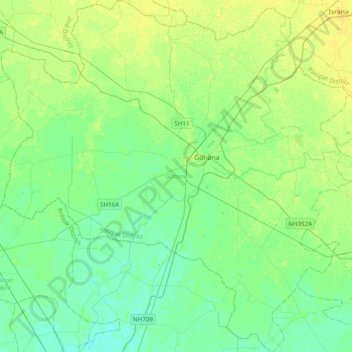
Name: Gohana topographic map, elevation, terrain.
Location: Gohana, Sonipat District, Haryana, India (28.94855 76.47453 29.28917 76.86485)
Average elevation: 745 ft
Minimum elevation: 722 ft
Maximum elevation: 771 ft
Other topographic maps
Click on a map to view its topography, its elevation and its terrain.
Sector 37D
India > Haryana > Gurugram District
Sector 37D, Gurgaon, Gurugram District, Haryana, India
Average elevation: 712 ft
Eiffel
India > Haryana > Gurugram District
Eiffel, Sohna, Gurugram District, Haryana, India
Average elevation: 830 ft
Emerald Bay
Emerald Bay, Sector 104, Gurgaon, Gurugram, Haryana, India
Average elevation: 705 ft
Central Park
Central Park, Sector 24, Gurgaon, Gurugram, Haryana, 122010, India
Average elevation: 814 ft
Malra
India > Haryana > Mahendragarh > Malra
Malra, Mahendragarh, Haryana, India
Average elevation: 837 ft
Ambala
India > Haryana > Ambala Cantt
Ambala, Ambala Cantt, Ambala, Haryana, 134002, India
Average elevation: 902 ft
Gurgaon
India > Haryana > Gurugram District
Gurgaon, Gurugram District, Haryana, India
Average elevation: 778 ft
Ferozepur Jhirka
India > Haryana > Ferozepur Jhirka > Ferozepur Jhirka
Ferozepur Jhirka, Nuh, Haryana, 122104, India
Average elevation: 840 ft
Sector 107
Sector 107, Gurgaon, Gurugram, Haryana, India
Average elevation: 696 ft
Sector 101
Sector 101, Gurgaon, Gurugram, Haryana, India
Average elevation: 705 ft
Paposa
India > Haryana > Bawani Khera
Paposa, Bawani Khera, Bhiwani district, Haryana, 127035, India
Average elevation: 712 ft