Geolocate

Lluyllucucha topographic map

Click on the map to display elevation.

About this map

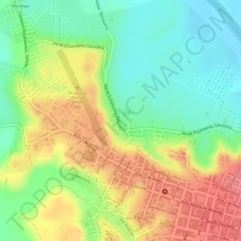
Name: Lluyllucucha topographic map, elevation, terrain.

Location: Lluyllucucha, Moyobamba, San Martín, Perú (-6.03165 -76.99482 -6.01172 -76.97180)

Average elevation: 2,753 ft

Minimum elevation: 2,625 ft

Maximum elevation: 2,890 ft

Other topographic maps

Click on a map to view its topography, its elevation and its terrain.

Provincia de Moyobamba

Perú > San Martín > Moyobamba

Average elevation: 2,979 ft

Playa Hermosa

Perú > San Martín > Moyobamba

Average elevation: 3,481 ft

Quillualpa

Perú > San Martín > Moyobamba

Average elevation: 3,711 ft

Tingana

Perú > San Martín > Moyobamba

Average elevation: 2,657 ft

Punta de San Juan

Perú > San Martín > Moyobamba

Average elevation: 2,746 ft

Parque Industrial

Perú > San Martín > Moyobamba > Parque Industrial

Average elevation: 2,822 ft

Gear up for your next adventure:

🧦Hiking Socks - Comfortable socks to prevent blisters on long hikes
🧣Merino Neck Gaiters - Multi-functional headwear for wind and sun protection
🥘Titanium Cookware - Durable, featherlight pots and pans for backpacking
💧Water Filtration Bottles - Safely drink from streams and lakes while exploring
🧦Merino Wool Socks - Moisture-wicking, blister-preventing socks for long treks

As an Amazon Associate, this site earns from qualifying purchases at no extra cost to you.