
Thank you for supporting this site ❤️
Make a donation
Make a donation
Gear up for your next adventure:
As an Amazon Associate, this site earns from qualifying purchases at no extra cost to you.
Tifra topographic map
Click on the map to display elevation.
Thank you for supporting this site ❤️
Make a donation
Make a donation
Gear up for your next adventure:
As an Amazon Associate, this site earns from qualifying purchases at no extra cost to you.
About this map
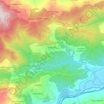
Name: Tifra topographic map, elevation, terrain.
Location: Tifra, Sidi Aich District, Bejaia, 06412, Algeria (36.62848 4.62347 36.69583 4.74372)
Average elevation: 1,864 ft
Minimum elevation: 203 ft
Maximum elevation: 4,541 ft
Thank you for supporting this site ❤️
Make a donation
Make a donation
Gear up for your next adventure:
As an Amazon Associate, this site earns from qualifying purchases at no extra cost to you.