
Make a donation
Gear up for your next adventure:
As an Amazon Associate, this site earns from qualifying purchases at no extra cost to you.
Chanceford Township topographic map
Click on the map to display elevation.
Make a donation
Gear up for your next adventure:
As an Amazon Associate, this site earns from qualifying purchases at no extra cost to you.
About this map
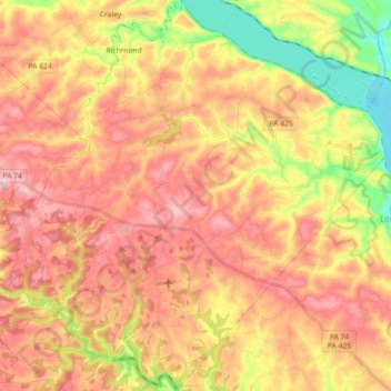
Name: Chanceford Township topographic map, elevation, terrain.
Average elevation: 630 ft
Minimum elevation: 167 ft
Maximum elevation: 974 ft
York County trails, hiking, mountain biking, running and outdoor activities
Make a donation
Gear up for your next adventure:
As an Amazon Associate, this site earns from qualifying purchases at no extra cost to you.
Other topographic maps
Click on a map to view its topography, its elevation and its terrain.
Freysville
United States > Pennsylvania > York County > Windsor Township > Freysville
Average elevation: 764 ft
Fairview Park
United States > Pennsylvania > York County > Fairview Township > Fairview Park
Average elevation: 614 ft
Make a donation
Gear up for your next adventure:
As an Amazon Associate, this site earns from qualifying purchases at no extra cost to you.
Airville
United States > Pennsylvania > York County > Lower Chanceford Township
Average elevation: 686 ft
Make a donation
Gear up for your next adventure:
As an Amazon Associate, this site earns from qualifying purchases at no extra cost to you.
Pinchot Lake
United States > Pennsylvania > York County > Warrington Township > Rossville > Alpine
Average elevation: 502 ft
Spring Plains
United States > Pennsylvania > York County > Springettsbury Township
Average elevation: 495 ft
Make a donation
Gear up for your next adventure:
As an Amazon Associate, this site earns from qualifying purchases at no extra cost to you.
Campbell Estates
United States > Pennsylvania > York County > West Manchester Township
Average elevation: 449 ft