
Make a donation
Gear up for your next adventure:
As an Amazon Associate, this site earns from qualifying purchases at no extra cost to you.
Ghermanville topographic map
Click on the map to display elevation.
Make a donation
Gear up for your next adventure:
As an Amazon Associate, this site earns from qualifying purchases at no extra cost to you.
About this map
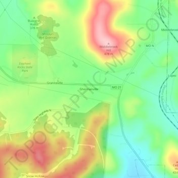
Name: Ghermanville topographic map, elevation, terrain.
Location: Ghermanville, Iron County, Missouri, 63623, United States (37.62894 -90.69012 37.66894 -90.65012)
Average elevation: 1,230 ft
Minimum elevation: 994 ft
Maximum elevation: 1,552 ft
Iron County trails, hiking, mountain biking, running and outdoor activities
Make a donation
Gear up for your next adventure:
As an Amazon Associate, this site earns from qualifying purchases at no extra cost to you.
Other topographic maps
Click on a map to view its topography, its elevation and its terrain.
Bell Mountain Wilderness
United States > Missouri > Iron County
The United States Congress designated the Bell Mountain Wilderness in 1980. The wilderness area now has a total of 9,027 acres (36.53 km2). Bell Mountain is located within the Potosi-Fredericktown Ranger District of the Mark Twain National Forest, south of Potosi, Missouri in the United States. The wilderness…
Average elevation: 1,227 ft