Geolocate

Higdon topographic map

Click on the map to display elevation.

About this map

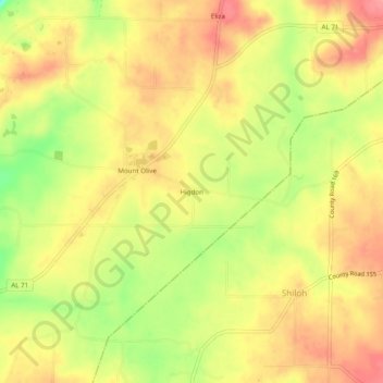
Name: Higdon topographic map, elevation, terrain.

Location: Higdon, Jackson County, Alabama, 35979, United States (34.82564 -85.63636 34.86564 -85.59636)

Average elevation: 1,378 ft

Minimum elevation: 1,194 ft

Maximum elevation: 1,496 ft

Jackson County trails, hiking, mountain biking, running and outdoor activities

Other topographic maps

Click on a map to view its topography, its elevation and its terrain.

Langston

United States > Alabama > Jackson County

Average elevation: 797 ft

Paint Rock

United States > Alabama > Jackson County

Average elevation: 810 ft

Pleasant Groves

United States > Alabama > Jackson County

Average elevation: 1,086 ft

Skyline

United States > Alabama > Jackson County

Average elevation: 1,276 ft

Hytop

United States > Alabama > Jackson County

Average elevation: 1,355 ft

Dutton

United States > Alabama > Jackson County

Average elevation: 1,345 ft

Scottsboro

United States > Alabama > Jackson County

Average elevation: 771 ft

Stevenson

United States > Alabama > Jackson County

Average elevation: 810 ft

Paint Rock

United States > Alabama > Jackson County

Average elevation: 817 ft

Pisgah

United States > Alabama > Jackson County > Pisgah

Average elevation: 1,375 ft

Gear up for your next adventure:

🧢Sun Protection Hats - Wide-brimmed and UPF-rated hats for high-altitude sun safety
🦺Reflective Outdoor Gear - Safety gear for low‑light conditions
👓Polarized Sunglasses - Outdoor sunglasses for glare reduction
☀️Outdoor Sunscreen - High protection sunscreen for outdoor activities
🌐World Map Poster - Decorative world maps with topographic info

As an Amazon Associate, this site earns from qualifying purchases at no extra cost to you.