Geolocate

Sugar Tree Ridge topographic map

Click on the map to display elevation.

About this map

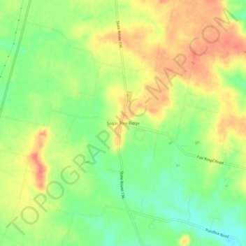
Name: Sugar Tree Ridge topographic map, elevation, terrain.

Location: Sugar Tree Ridge, Highland County, Ohio, United States (39.05034 -83.68187 39.09034 -83.64187)

Average elevation: 1,063 ft

Minimum elevation: 968 ft

Maximum elevation: 1,152 ft

Highland County trails, hiking, mountain biking, running and outdoor activities

Other topographic maps

Click on a map to view its topography, its elevation and its terrain.

Rocky Fork Lake

United States > Ohio > Highland County

Average elevation: 955 ft

Mowrystown

United States > Ohio > Highland County

Average elevation: 981 ft

Lynchburg

United States > Ohio > Highland County

Average elevation: 1,017 ft

Hillsboro

United States > Ohio > Highland County

Average elevation: 1,027 ft

Highland

United States > Ohio > Highland County

Average elevation: 1,070 ft

Paint Creek Lake

United States > Ohio > Highland County

Average elevation: 909 ft

Gear up for your next adventure:

🛰️Satellite Messengers - Emergency SOS and two-way messaging for off-grid adventures
🧣Merino Neck Gaiters - Multi-functional headwear for wind and sun protection
🏕️Family Camping Gear - Essentials for group camping trips
🧭Orienteering Set - Complete compass and map reading kit
🛡️Bear Spray Outdoor - Protection in bear country hikes

As an Amazon Associate, this site earns from qualifying purchases at no extra cost to you.