Geolocate

Mowrystown topographic map

Click on the map to display elevation.

About this map

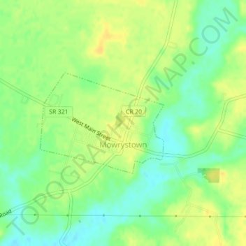
Name: Mowrystown topographic map, elevation, terrain.

Location: Mowrystown, Highland County, Ohio, 45155, United States (39.03522 -83.76028 39.04629 -83.74279)

Average elevation: 981 ft

Minimum elevation: 938 ft

Maximum elevation: 1,017 ft

Highland County trails, hiking, mountain biking, running and outdoor activities

Other topographic maps

Click on a map to view its topography, its elevation and its terrain.

Rainsboro

United States > Ohio > Highland County

Average elevation: 928 ft

Samantha

United States > Ohio > Highland County

Average elevation: 1,132 ft

East Monroe

United States > Ohio > Highland County

Average elevation: 974 ft

Taylorsville

United States > Ohio > Highland County

Average elevation: 1,004 ft

Sugar Tree Ridge

United States > Ohio > Highland County

Average elevation: 1,063 ft

Pricetown

United States > Ohio > Highland County

Average elevation: 1,024 ft

New Petersburg

United States > Ohio > Highland County

Average elevation: 945 ft

New Market

United States > Ohio > Highland County

Average elevation: 1,109 ft

Marshall

United States > Ohio > Highland County

Average elevation: 981 ft

Hollowtown

United States > Ohio > Highland County

Average elevation: 1,024 ft

Hoagland

United States > Ohio > Highland County

Average elevation: 1,096 ft

Folsom

United States > Ohio > Highland County

Average elevation: 955 ft

Carmel

United States > Ohio > Highland County

Average elevation: 997 ft

Dodsonville

United States > Ohio > Highland County

Average elevation: 1,014 ft

East Danville

United States > Ohio > Highland County

Average elevation: 1,047 ft

Elmville

United States > Ohio > Highland County

Average elevation: 837 ft

Fairfax

United States > Ohio > Highland County

Average elevation: 1,007 ft

Boston

United States > Ohio > Highland County

Average elevation: 1,004 ft

Belfast

United States > Ohio > Highland County

Average elevation: 876 ft

Berrysville

United States > Ohio > Highland County

Average elevation: 1,017 ft

Buford

United States > Ohio > Highland County

Average elevation: 961 ft

Allensburg

United States > Ohio > Highland County

Average elevation: 1,027 ft

Russell

United States > Ohio > Highland County

Average elevation: 1,053 ft

Gear up for your next adventure:

📦Dry Bags Set - Waterproof storage for electronics and clothes
🗺️NatGeo Topo Maps - High-quality waterproof printed topographic maps of US Parks
🧭GPS Watch Accessories - Bands and chargers for GPS watches
🧣Merino Neck Gaiters - Multi-functional headwear for wind and sun protection
👟Men's Trail Runners - Lightweight footwear for fast-paced exploration and light hiking

As an Amazon Associate, this site earns from qualifying purchases at no extra cost to you.