Geolocate

Naasug topographic map

Click on the map to display elevation.

About this map

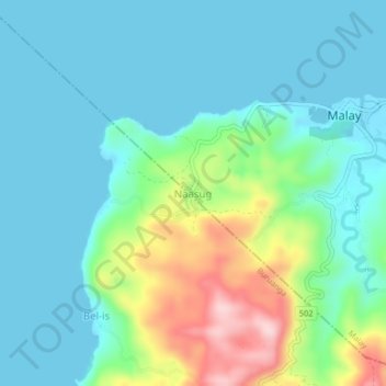
Name: Naasug topographic map, elevation, terrain.

Location: Naasug, Malay, Aklan, Western Visayas, 5608, Philippines (11.87195 121.87386 11.91195 121.91386)

Average elevation: 184 ft

Minimum elevation: -3 ft

Maximum elevation: 774 ft

Other topographic maps

Click on a map to view its topography, its elevation and its terrain.

Potol

Philippines > Aklan > Malay > Argao > Potol

Average elevation: 92 ft

Boracay

Philippines > Aklan > Malay > Caticlan

Average elevation: 20 ft

Punta Bunga Beach

Philippines > Aklan > Malay

Average elevation: 52 ft

Ilig Iligan Beach

Philippines > Aklan > Malay

Average elevation: 43 ft

Boracay

Philippines > Aklan > Malay

Average elevation: 20 ft

Boracay

Philippines > Aklan > Malay

Average elevation: 20 ft

Boracay

Philippines > Aklan > Malay

Average elevation: 20 ft

Boracay

Philippines > Aklan > Malay > Caticlan

Average elevation: 20 ft

Manoc-Manoc

Philippines > Aklan > Malay

Average elevation: 16 ft

Gear up for your next adventure:

🧭GPS Watch Accessories - Bands and chargers for GPS watches
🧴Hand Sanitizer - Keep hands clean while hiking
🗺️NatGeo Topo Maps - High-quality waterproof printed topographic maps of US Parks
🪶Trail Camera - Capture wildlife on your hikes
🔥Fast-Boil Camping Stoves - Efficient cooking systems for quick trail meals

As an Amazon Associate, this site earns from qualifying purchases at no extra cost to you.