Geolocate

者米拉祜族乡 topographic map

Interactive map

Click on the map to display elevation.

About this map

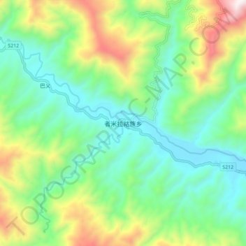
Name: 者米拉祜族乡 topographic map, elevation, terrain.

Location: 者米拉祜族乡, 金平苗族瑶族傣族自治县, 红河哈尼族彝族自治州, 云南省, 中国 (22.73708 102.65664 22.81708 102.73664)

Average elevation: 2,789 ft

Minimum elevation: 1,640 ft

Maximum elevation: 5,367 ft

Other topographic maps

Click on a map to view its topography, its elevation and its terrain.

金水河镇

中国 > 云南省 > 金平苗族瑶族傣族自治县

金水河镇, 金平苗族瑶族傣族自治县, 红河哈尼族彝族自治州, 云南省, 中国

Average elevation: 1,877 ft

勐拉镇

中国 > 云南省 > 金平苗族瑶族傣族自治县

勐拉镇, 金平苗族瑶族傣族自治县, 红河哈尼族彝族自治州, 云南省, 中国

Average elevation: 1,706 ft

大寨乡

中国 > 云南省 > 金平苗族瑶族傣族自治县

大寨乡, 金平苗族瑶族傣族自治县, 红河哈尼族彝族自治州, 云南省, 中国

Average elevation: 4,800 ft

牛角坪

中国 > 云南省 > 金平苗族瑶族傣族自治县

牛角坪, 金平苗族瑶族傣族自治县, 红河哈尼族彝族自治州, 云南省, 中国

Average elevation: 4,281 ft

浪板

中国 > 云南省 > 金平苗族瑶族傣族自治县

浪板, 金平苗族瑶族傣族自治县, 红河哈尼族彝族自治州, 云南省, 中国

Average elevation: 2,723 ft

金平县

中国 > 云南省 > 金平苗族瑶族傣族自治县

金平县, 金平苗族瑶族傣族自治县, 红河哈尼族彝族自治州, 云南省, 中国

Average elevation: 4,219 ft