
Kargaly District topographic map
Interactive map
Click on the map to display elevation.
About this map
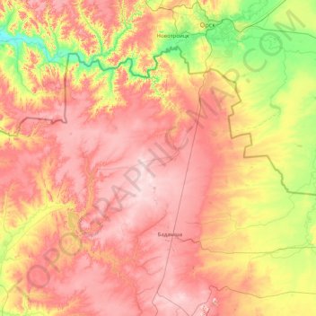
Name: Kargaly District topographic map, elevation, terrain.
Location: Kargaly District, Aktobe Region, 030500, Kazakhstan (50.44843 57.28367 51.16228 58.87799)
Average elevation: 1,066 ft
Minimum elevation: 515 ft
Maximum elevation: 1,673 ft
Other topographic maps
Click on a map to view its topography, its elevation and its terrain.
Khromtau
Kazakhstan > Aktobe Region > Khromtau District
Khromtau, Khromtau District, Aktobe Region, 031100, Kazakhstan
Average elevation: 1,388 ft
Mugalzhar District
Mugalzhar District, Aktobe Region, Kazakhstan
Average elevation: 915 ft
Badamsha
Kazakhstan > Aktobe Region > Kargaly District > Badamsha
Badamsha, Kargaly District, Aktobe Region, 030500, Kazakhstan
Average elevation: 1,394 ft
Yrgyz District
Kazakhstan > Aktobe Region > Yrgyz District
Yrgyz District, Aktobe Region, 030400, Kazakhstan
Average elevation: 423 ft
Aktobe
Kazakhstan > Aktobe Region > Aktobe
Aktobe, Актобе Г.А., Aktobe Region, 030000, Kazakhstan
Average elevation: 787 ft