
Mugalzhar District topographic map
Interactive map
Click on the map to display elevation.
About this map
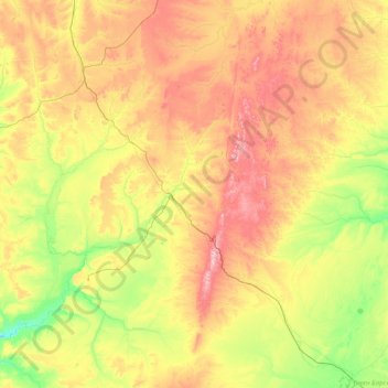
Name: Mugalzhar District topographic map, elevation, terrain.
Location: Mugalzhar District, Aktobe Region, Kazakhstan (47.78804 56.50934 49.87278 59.60018)
Average elevation: 915 ft
Minimum elevation: 407 ft
Maximum elevation: 2,119 ft
Other topographic maps
Click on a map to view its topography, its elevation and its terrain.
Khromtau
Kazakhstan > Aktobe Region > Khromtau District
Khromtau, Khromtau District, Aktobe Region, 031100, Kazakhstan
Average elevation: 1,388 ft
Kargaly District
Kargaly District, Aktobe Region, 030500, Kazakhstan
Average elevation: 1,066 ft
Badamsha
Kazakhstan > Aktobe Region > Kargaly District > Badamsha
Badamsha, Kargaly District, Aktobe Region, 030500, Kazakhstan
Average elevation: 1,394 ft
Yrgyz District
Kazakhstan > Aktobe Region > Yrgyz District
Yrgyz District, Aktobe Region, 030400, Kazakhstan
Average elevation: 423 ft
Aktobe
Kazakhstan > Aktobe Region > Aktobe
Aktobe, Актобе Г.А., Aktobe Region, 030000, Kazakhstan
Average elevation: 787 ft