Geolocate

Bisisthal topographic map

Interactive map

Click on the map to display elevation.

About this map

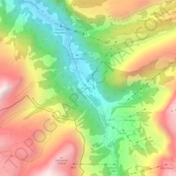
Name: Bisisthal topographic map, elevation, terrain.

Location: Bisisthal, Muotathal, Schwyz, 6436, Suisse (46.92303 8.81120 46.96303 8.85120)

Average elevation: 4,518 ft

Minimum elevation: 2,497 ft

Maximum elevation: 6,775 ft

Other topographic maps

Click on a map to view its topography, its elevation and its terrain.

Glattalp

Suisse > Schwyz > Schwyz > Muotathal

Glattalp, Muotathal, Schwyz, 6436, Suisse

Average elevation: 6,355 ft

Guggeli

Suisse > Schwyz > Schwyz > Stalden

Guggeli, Stalden, Muotathal, Schwyz, 6436, Suisse

Average elevation: 3,484 ft

Schwytz

Suisse > Schwyz > Schwyz

Schwytz, Schwyz, Suisse

Average elevation: 3,064 ft

Muotathal

Suisse > Schwyz > Schwyz

Muotathal, Schwyz, 6436, Suisse

Average elevation: 4,721 ft

Ingenbohl

Suisse > Schwyz > Schwyz

Ingenbohl, Schwyz, 6440, Suisse

Average elevation: 2,211 ft

Rickenbach

Suisse > Schwyz > Schwyz > Schwytz

Rickenbach, Schwytz, Schwyz, 6432, Suisse

Average elevation: 2,464 ft

Rigi

Suisse > Schwyz > Schwyz > Arth

Rigi, Arth, Schwyz, 6356, Suisse

Average elevation: 4,150 ft