
Make a donation
Gear up for your next adventure:
As an Amazon Associate, this site earns from qualifying purchases at no extra cost to you.
Muotathal topographic map
Click on the map to display elevation.
Make a donation
Gear up for your next adventure:
As an Amazon Associate, this site earns from qualifying purchases at no extra cost to you.
About this map
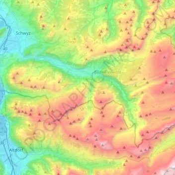
Name: Muotathal topographic map, elevation, terrain.
Location: Muotathal, Schwyz, 6436, Suisse (46.88529 8.66729 47.02694 8.97164)
Average elevation: 4,721 ft
Minimum elevation: 1,411 ft
Maximum elevation: 9,711 ft
Make a donation
Gear up for your next adventure:
As an Amazon Associate, this site earns from qualifying purchases at no extra cost to you.
Other topographic maps
Click on a map to view its topography, its elevation and its terrain.
Make a donation
Gear up for your next adventure:
As an Amazon Associate, this site earns from qualifying purchases at no extra cost to you.
Stoos
La station est reliée à la vallée depuis le lieu-dit Schlattli, par le funiculaire Schwyz-Stoos qui est le plus raide au monde avec une pente atteignant les 110 % - ainsi qu'un petit téléphérique à faible débit - depuis Morschach. Le petit parking payant situé à proximité immédiate du funiculaire…
Average elevation: 4,042 ft
Make a donation
Gear up for your next adventure:
As an Amazon Associate, this site earns from qualifying purchases at no extra cost to you.