
Bashiqa topographic map
Click on the map to display elevation.
About this map
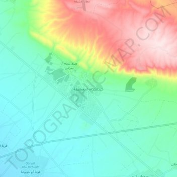
Name: Bashiqa topographic map, elevation, terrain.
Average elevation: 1,312 ft
Minimum elevation: 928 ft
Maximum elevation: 2,159 ft
Other topographic maps
Click on a map to view its topography, its elevation and its terrain.
Nimrud
Iraq > Nineveh Governorate > Qaryat an Namaniyah
Subsequent work was by the Directorate of Antiquities of the Republic of Iraq (1956, 1959–60, 1969–78 and 1982–92), the Polish Centre of Mediterranean Archaeology University of Warsaw directed by Janusz Meuszyński (1974–76), Paolo Fiorina (1987–89) with the Centro Ricerche Archeologiche e Scavi di…
Average elevation: 666 ft