Geolocate

Nys topographic map

Click on the map to display elevation.

About this map

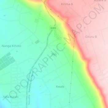
Name: Nys topographic map, elevation, terrain.

Location: Nys, Naivasha East ward, Naivasha, Nakuru, Rift Valley, Kenya (-0.67648 36.46764 -0.63648 36.50764)

Average elevation: 7,510 ft

Minimum elevation: 7,087 ft

Maximum elevation: 8,120 ft

Gear up for your next adventure:

🪶Camp Gear Gift Set - Perfect gift bundle for outdoor fans
🧭Hiking Compass - Precision compass for reliable navigation in the wilderness
🪶Fire Starter Kit - Reliable fire starter for survival and camping
😴Insulated Sleeping Pads - Compact and warm pads for high-elevation camping
🍳Camping Cook Set - Complete cookware for outdoor meals

As an Amazon Associate, this site earns from qualifying purchases at no extra cost to you.