
Make a donation
Gear up for your next adventure:
As an Amazon Associate, this site earns from qualifying purchases at no extra cost to you.
Krakow topographic map
Click on the map to display elevation.
Make a donation
Gear up for your next adventure:
As an Amazon Associate, this site earns from qualifying purchases at no extra cost to you.
About this map
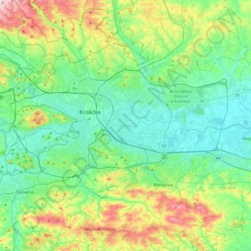
Name: Krakow topographic map, elevation, terrain.
Location: Krakow, Lesser Poland Voivodeship, Poland (49.96767 19.79224 50.12613 20.21735)
Average elevation: 846 ft
Minimum elevation: 614 ft
Maximum elevation: 1,499 ft
Make a donation
Gear up for your next adventure:
As an Amazon Associate, this site earns from qualifying purchases at no extra cost to you.
Other topographic maps
Click on a map to view its topography, its elevation and its terrain.
Klein
Poland > Lesser Poland Voivodeship > Oświęcim County > Stawy Monowskie > Zalesie
Average elevation: 741 ft
Svinica / Świnica
Poland > Lesser Poland Voivodeship > Tatra County > Brzegi
Average elevation: 6,093 ft
Make a donation
Gear up for your next adventure:
As an Amazon Associate, this site earns from qualifying purchases at no extra cost to you.
Wielki Giewont
Poland > Lesser Poland Voivodeship > Tatra County > Zakopane
Average elevation: 4,849 ft
Podzamcze
Poland > Lesser Poland Voivodeship > Kraków County > Korzkiew > Podzamcze
Average elevation: 1,053 ft
Make a donation
Gear up for your next adventure:
As an Amazon Associate, this site earns from qualifying purchases at no extra cost to you.
Podkościele
Poland > Lesser Poland Voivodeship > Tarnów County > Wola Rzędzińska
Average elevation: 787 ft
Morskie Oko
Poland > Lesser Poland Voivodeship > Tatra County > Brzegi
Morskie Oko at the foothill of Tatra Mountains in southern Poland which average 2,000 metres (6,600 ft) in elevation
Average elevation: 5,738 ft
Make a donation
Gear up for your next adventure:
As an Amazon Associate, this site earns from qualifying purchases at no extra cost to you.
Tatry
Poland > Lesser Poland Voivodeship > Tatra County > Zakopane
The Tatras lie in the temperate zone of Central Europe. They are an important barrier to the movements of air masses. Their mountainous topography causes one of the most diverse climates in that region.
Average elevation: 5,404 ft