
Make a donation
Gear up for your next adventure:
As an Amazon Associate, this site earns from qualifying purchases at no extra cost to you.
Pacific Palisades topographic map
Click on the map to display elevation.
Make a donation
Gear up for your next adventure:
As an Amazon Associate, this site earns from qualifying purchases at no extra cost to you.
Pacific Palisades
Pacific Palisades was formally founded in 1921 by a Methodist organization, and in the years that followed became a refuge for Jewish artists and intellectuals fleeing the Holocaust. The Palisades would later be sought after by celebrities and other high-profile individuals seeking privacy. It is known for its seclusion and for being a close-knit community with a small-town feel, as well as its Mediterranean climate, hilly topography, natural environment, and abundance of parkland and hiking trails, 3-mile (4.8 km) strip of coastline, and for being home to a number of architecturally significant homes.
Make a donation
Gear up for your next adventure:
As an Amazon Associate, this site earns from qualifying purchases at no extra cost to you.
About this map
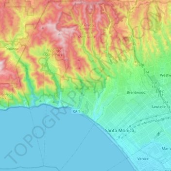
Name: Pacific Palisades topographic map, elevation, terrain.
Average elevation: 643 ft
Minimum elevation: -7 ft
Maximum elevation: 2,142 ft
Los Angeles County trails, hiking, mountain biking, running and outdoor activities
Make a donation
Gear up for your next adventure:
As an Amazon Associate, this site earns from qualifying purchases at no extra cost to you.
Other topographic maps
Click on a map to view its topography, its elevation and its terrain.
Santa Ynez Reservoir
United States > California > Los Angeles County > Los Angeles
Average elevation: 1,007 ft
Mount Lukens
United States > California > Los Angeles County > Los Angeles
It is in the Sunland-Tujunga community within the northeast corner of the city of Los Angeles, above the Crescenta Valley. The summit, at 5,075 feet (1,547 m) in elevation, is the highest point within the city limits. The summit's elevation makes Los Angeles the city with the largest difference between high…
Average elevation: 3,858 ft
Los Angeles River
United States > California > Los Angeles County > Los Angeles
Average elevation: 797 ft
Make a donation
Gear up for your next adventure:
As an Amazon Associate, this site earns from qualifying purchases at no extra cost to you.
Mission Junction
United States > California > Los Angeles County > Los Angeles
Average elevation: 338 ft
Thenard
United States > California > Los Angeles County > Los Angeles > Thenard
Average elevation: 26 ft
Augustus F. Hawkins Natural Park
United States > California > Los Angeles County > Los Angeles
Average elevation: 180 ft
Maguire Gardens
United States > California > Los Angeles County > Los Angeles
Average elevation: 325 ft
Make a donation
Gear up for your next adventure:
As an Amazon Associate, this site earns from qualifying purchases at no extra cost to you.
Genesee Avenue Park
United States > California > Los Angeles County > Los Angeles
Average elevation: 108 ft