
Thank you for supporting this site ❤️
Make a donation
Make a donation
Gear up for your next adventure:
As an Amazon Associate, this site earns from qualifying purchases at no extra cost to you.
Fiscal topographic map
Click on the map to display elevation.
Thank you for supporting this site ❤️
Make a donation
Make a donation
Gear up for your next adventure:
As an Amazon Associate, this site earns from qualifying purchases at no extra cost to you.
About this map
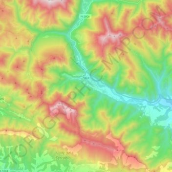
Name: Fiscal topographic map, elevation, terrain.
Location: Fiscal, Sobrarbe, Huesca, Aragon, 22373, Spain (42.40784 -0.18298 42.56743 0.03498)
Average elevation: 4,026 ft
Minimum elevation: 2,152 ft
Maximum elevation: 6,627 ft
Thank you for supporting this site ❤️
Make a donation
Make a donation
Gear up for your next adventure:
As an Amazon Associate, this site earns from qualifying purchases at no extra cost to you.
Other topographic maps
Click on a map to view its topography, its elevation and its terrain.
Muleta
Spain > Aragon > Matarraña / Matarranya > Valderrobres / Vall de Roures
Average elevation: 3,711 ft