
Make a donation
Gear up for your next adventure:
As an Amazon Associate, this site earns from qualifying purchases at no extra cost to you.
Yunlin County topographic map
Click on the map to display elevation.
Make a donation
Gear up for your next adventure:
As an Amazon Associate, this site earns from qualifying purchases at no extra cost to you.
Yunlin County
Penglai Waterfall is located in Penny's Water Creek Valley on the east side of the Caoling settlement in Gukeng Township. It belongs to the Zhuoshui River Basin. The altitude of the waterfall is about 920 meters, and the drop is about 70 meters. It is listed as one of the ten scenic spots in Caoling.
Make a donation
Gear up for your next adventure:
As an Amazon Associate, this site earns from qualifying purchases at no extra cost to you.
About this map
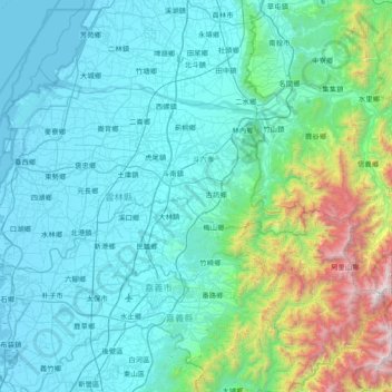
Name: Yunlin County topographic map, elevation, terrain.
Location: Yunlin County, Taiwan (23.41123 119.98249 23.86622 120.73615)
Average elevation: 1,283 ft
Minimum elevation: -7 ft
Maximum elevation: 9,350 ft
Make a donation
Gear up for your next adventure:
As an Amazon Associate, this site earns from qualifying purchases at no extra cost to you.
Other topographic maps
Click on a map to view its topography, its elevation and its terrain.
Make a donation
Gear up for your next adventure:
As an Amazon Associate, this site earns from qualifying purchases at no extra cost to you.
Yushan
Taiwan > Nantou County > Xinyi Township
Yu Shan or Yushan, also known as Mount Jade, Jade Mountain, or Mount Yu, and known as Mount Niitaka during Japanese rule, is the highest mountain in Taiwan at 3,952 m (12,966 ft) above sea level, giving Taiwan the 4th-highest maximum elevation of any island in the world. It is the highest point in the western…
Average elevation: 11,191 ft
Make a donation
Gear up for your next adventure:
As an Amazon Associate, this site earns from qualifying purchases at no extra cost to you.
Make a donation
Gear up for your next adventure:
As an Amazon Associate, this site earns from qualifying purchases at no extra cost to you.
Make a donation
Gear up for your next adventure:
As an Amazon Associate, this site earns from qualifying purchases at no extra cost to you.
Make a donation
Gear up for your next adventure:
As an Amazon Associate, this site earns from qualifying purchases at no extra cost to you.
Make a donation
Gear up for your next adventure:
As an Amazon Associate, this site earns from qualifying purchases at no extra cost to you.
Make a donation
Gear up for your next adventure:
As an Amazon Associate, this site earns from qualifying purchases at no extra cost to you.
Make a donation
Gear up for your next adventure:
As an Amazon Associate, this site earns from qualifying purchases at no extra cost to you.
Make a donation
Gear up for your next adventure:
As an Amazon Associate, this site earns from qualifying purchases at no extra cost to you.
Yilan County
Yilan County is located in the northeastern Taiwan Island which covers an area of 2,143 km2. The longest distance from east to west is 63 km and from north to south is 74 km. From the mountain areas downwards, the land falls in altitude in the stages of mountains, alleys, alluvial plains, lowlands, swamps,…
Average elevation: 1,365 ft
Make a donation
Gear up for your next adventure:
As an Amazon Associate, this site earns from qualifying purchases at no extra cost to you.
Make a donation
Gear up for your next adventure:
As an Amazon Associate, this site earns from qualifying purchases at no extra cost to you.