
Amay topographic map
Interactive map
Click on the map to display elevation.
About this map
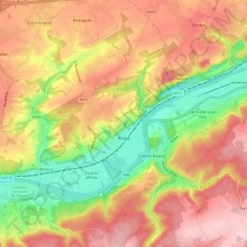
Name: Amay topographic map, elevation, terrain.
Location: Amay, Huy, Liège, Wallonia, 4540, Belgium (50.51631 5.26202 50.59187 5.35023)
Average elevation: 518 ft
Minimum elevation: 151 ft
Maximum elevation: 814 ft
Other topographic maps
Click on a map to view its topography, its elevation and its terrain.
Grand-Marchin
Belgium > Liège > Huy > Marchin
Grand-Marchin, Marchin, Huy, Liège, Wallonia, 4570, Belgium
Average elevation: 738 ft
Trou Dubois
Belgium > Liège > Huy > Wanze > Moha > Le Taillis
Trou Dubois, Rue du Madot, Les communes, Le Taillis, Moha, Wanze, Huy, Liège, Wallonia, 4520, Belgium
Average elevation: 427 ft