
Marneffe topographic map
Interactive map
Click on the map to display elevation.
About this map
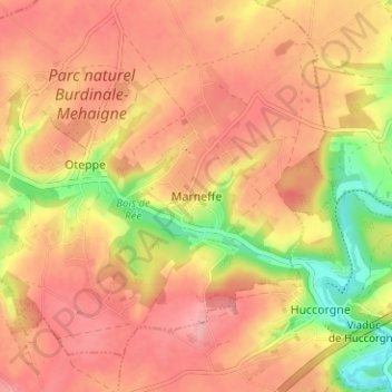
Name: Marneffe topographic map, elevation, terrain.
Location: Marneffe, Huy, Liège, Wallonia, 4210, Belgium (50.55910 5.12489 50.59910 5.16489)
Average elevation: 509 ft
Minimum elevation: 289 ft
Maximum elevation: 630 ft
Other topographic maps
Click on a map to view its topography, its elevation and its terrain.
Grand-Marchin
Belgium > Liège > Huy > Marchin
Grand-Marchin, Marchin, Huy, Liège, Wallonia, 4570, Belgium
Average elevation: 738 ft
Trou Dubois
Belgium > Liège > Huy > Wanze > Moha > Le Taillis
Trou Dubois, Rue du Madot, Les communes, Le Taillis, Moha, Wanze, Huy, Liège, Wallonia, 4520, Belgium
Average elevation: 427 ft